

Project “Adaptation of a modern system for water and land resources monitoring and water balance (water requirement) modeling in the conditions of the Aral Sea region with a view of combating salinization and increasing land productivity. Adaptation of water planning to climatic and hydrogeological changes”


Client: Agency for Innovative Development of the Republic of Uzbekistan (former Ministry of Innovation of RUz) as part of the Uzbek-Japan Joint International Research Development Program “SATREPS”.
Executor: Scientific-Information Center of ICWC
Duration: May 2022 – May 2025
Project Goalа: Adapting the modern monitoring system and, on this basis, modeling water resources management under conditions of the Aral Sea Region.
Project Objectives: Development of models for assessment and determination of crop water requirements of irrigated crops (REQWAT) under arid and salinization conditions (REQWATS).
Cooperation within the framework of the “SATREPS” program: Program “Development of Innovative Climate Resilient Technologies for Monitoring and Controlling of Water Use Efficiency and Impact of Salinization on Crop Productivity and Livelihood in Aral Sea region”.
utputs for May-December 2022:
Preparatory work was done in four areas from May to December 2022:
(1) selection of pilot sites;
(2) modeling of crop water requirements;
(3) RS-based mapping of soil salinity in the selected sites;
(4) participation in project events.
1. Selection of pilot sites
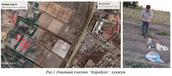
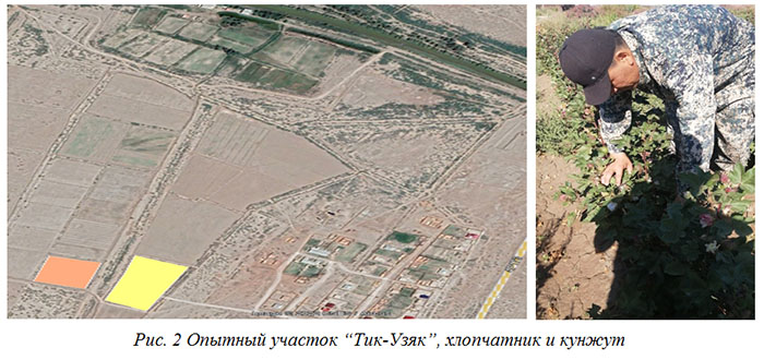
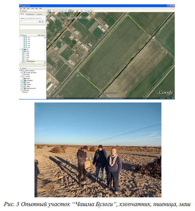
Three pilot sites were selected for research: “Karabuga” in Karauzyak district, “Tik-Uzyak” in Muynak district and “Chashma Bulogi” in Ellikkala district.
The “Karabuga” pilot site is a site for joint research with Japanese experts where Japanese equipment is installed, including a weather station with radar. This will facilitate the application of modern research methods.
The “Tik- Uzyak” pilot site is a research polygon of the International Innovation Center for the Aral Sea Basin under the President of the Republic of Uzbekistan (IICAS) that provided baseline information for testing the research version of the REQWAT model in 2022.
The "Chashma Bulogi" pilot site was chosen to study the right bank of the Amu Darya River, a saline soil zone and to test REQWATS in GIS and IRS environment.
2. Modeling of crop water requirements
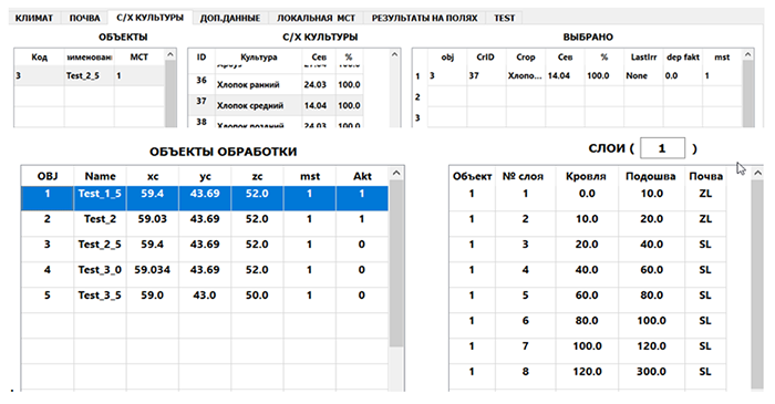
2.1. By December 2022, a research version of the REQWAT model for calculating crop water requirements has been developed.
The model is designed to determine crop irrigation regimes for main crops based on calculation of reference evapotranspiration (ETo). The model follows the “from simple to complex” principle. In case of the model, this implies the possibility to perform calculations for different sets of input data. The model is developed on the basis of modules. Each new algorithm is executed as a separate module and can be included or excluded from the calculation as the user wishes.
The model uses the following input data:
Object processing block
- GIS-file with object processing polygons (WGS-84 projection)
- DEM-text files with Earth surface altitudes
Climate data block
- Climate data in the form of a database containing information on main weather stations in Uzbekistan for a period of time as long as possible.
- The data from closest to objects weather stations for 3 months (before sowing) of the calculation year.
Soil data block
- Soil map (WGS-84 projection) covering the processing objects and containing soil texture of the root zone
Contribution from groundwater block
- Ten-day groundwater maps or tables on groundwater depths at rayon level
- Soil map (WGS-84 projection) covering the processing objects and containing granulometric composition of the root zone
Salinity block
- Salinity map (WGS-84 projection) for pre-sowing period generated with the use of satellite images. The map should cover polygons of processing objects
- Table of salinity by field samples, with indication of coordinates and dates of sampling
Crop block
- Crop coefficient tables
- Yield response table Crop development stage correction block
- Database table with average daily temperature
2.2. A research version of the REQWAT model for cotton and sesame is tested in the IICAS’ “Tik-Uzyak” pilot site in Muynak district
The following are examples of REQWAT testing:
The work on model testing is continued, and the algorithm for REQWATS model is under development.
3. Soil salinity mapping
During the reporting period, remote sensing (RS) expert reviewed literature, collected and processed the data on water, land conditions, processed Sentinel-2 images for the selected Ellikkala district in the Republic of Karakalpakstan. Additionally, the statistical data analysis was conducted, paper maps were scanned and referenced to the WGS-84 coordinates, and cartographic data was compared to select test fields in the area.
Based on the results of stratification and field visit to 8 irrigated fields of different salinity in Ellikkala district (August 24-28, 2022), three fields (#6-8) of cotton-wheat rotation in “Ellikkala gallakori” farm were selected for field tests in 2023-2024 as well as to collect data for REGWAT и REGWATS tests.
In the next stage, it is planned to equip the test fields with modern devices and conduct observations in these fields to develop a soil salinity mapping methodology based on RS-data.
4. Participation in events
On September 19-20, 2022, the 1st Joint Coordination Committee (JCC) and kick-off workshop on “Development of innovative climate resilient technologies for monitoring and controlling of water use efficiency and impact of salinization on crop productivity and livelihood in Aral Sea basin” was held at the Ministry of Innovative Development as a part of the “SATREPS” program.
The workshop was attended by scientists from Japanese universities, as well as high officials and experts implementing the project in Uzbekistan. Opening and welcoming remarks were made by representatives of the Ministry of Innovative Development, representatives of the Japanese part: JICA (Dr. Miyazaki), Japan Science and Technology Agency (Prof. Yamaguchi). The overview of the SATREPS project in Uzbekistan was presented by Prof. Tanaka, and the overview of project goals was presented by the Ministry of Innovative Development of the Republic of Uzbekistan.
Director of SIC ICWC, D. Ziganshina and project executors, G. Stulina and I. Ruziev took part in the workshop as well. The Project Manager, G. Stulina made a presentation on the goals and objectives of the project implemented by SIC ICWC within the framework of SATREPS program and described brief results of the work for May-August 2022.
On December 16, 2022, the Environmental Forum was organized by the Innovation Center for the Aral Sea Region in Nukus, Karakalpakstan. Representatives of Uzbek government agencies, international organizations, environmental organizations and University students took part in the Forum. Objective of the Forum was to introduce innovative scientific efforts of young researchers on environmental improvement in the Aral Sea Region. Five reports of young researchers were presented at the Forum. Islom Ruziev, project executor made the report on “Assessment of environmental conditions of water bodies in Southern Aral region.”