
Assessing Land Value Changes and developing a Discussion-Support-Tool for Improved Land Use Planning in the Irrigated Lowlands of Central Asia (LaVaCCA)
Background
Immense losses of land productivity have been observed on eight million hectares of irrigated agricultural land in Central Asia (CA) during the past decades. Especially the irrigated lowlands of the Amu Darya and Syr Darya Rivers are affected by land degradation (LD) problems. Despite first attempts to derive different types of land production related indicators, it remains uncertain, to which factors a change or trend of land production can be assigned. One major shortcoming is the generally lack of spatially explicit data. This situation hampers the assessment of land value, i.e. an economic assessment of land use options and, as a consequence, decision makers and planers in spatially targeting and implementing rehabilitation measures.
The proposed research addresses the identification of hotspots of decreasing land production and gaining knowledge about the drivers of change in land production and LD by analyzing socio-economic and ecological indicators. Economic assessments of land use options under given ecological conditions will be elaborated. A strong methodological focus is set on remote sensing, geographical information systems (GIS), indicator systems, land use modelling, and economic optimization. The generated information will be bundled and presented as a tool of discussion support for politicians and decision makers in their efforts to increase food security and combat environmental degradation in the irrigated areas of CA.
Goal:
Investigation of the development of land use (LU) change and production dynamics of the irrigated cropland in the lowlands of the Aral Sea Basin.
Specific objectives:
- investigating the temporal development of irrigated LU and crop yields considering LU changes (rotations, land abandonment);
- detecting indicators explaining production change by combining ecological (including production inputs like water), infrastructure, and socio-economic variables (incl. demographic development);
- using the resulting driving forces of production change in their meaning as indicators e.g. for specific changes in LP or LD. The aim is to use the indicators in their full range of meanings and thus remaining open for all reasons having caused LU and production changes and in turn productivity losses.
The objectives of the project are in compliance with the Millennium Development Goals of eradicating poverty and achieving food and water security, respectively. They agree with the United Nations conventions on desertification/land degradation (UNCCD) and climate change (FCCC) as well as with the “Strategy for a New Partnership between the EU and Central Asia” formulated by the EU during Germany’s Presidency of the EU in 2007.
The research addresses:
- the identification of hotspots of change in land use and production
- gain knowledge about the drivers of this change by analyzing socio-economic and ecological indicators with the aim to enable spatial explicit recommendations for rehabilitation of degraded irrigated ecosystems.
Scientific merit:
- The use of remote sensing, GIS and spatial modelling will help to identify on various scales hotspots of production change and explanatory variables on these scales. This can provide important information on land use also for the irrigation systems, i.e. crop types, or (biomass) production status over large areas but with a high level of spatial detail;
- The quantification of production and LU changes in relation to land productivity can support assessments of land value change and elaboration of economically sound options of land use.
Study area:
Study area is located in the irrigated lowlands of the Amu Darya (Khorezm and Karakalpakstan in Uzbekistan) and Syr Darya (Kyzylorda in Kazakhstan) River Basins. Three focus regions within the study area, namely “Kulavat” irrigation command area in Khorezm and Ellikkala district in Karakalpakstan, and Kazalisk district in Kyzylorda have been selected.
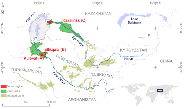
Study area in the irrigated lowlands of the Amu Darya and Syr Darya Rivers
Main expected outcomes:
- a comprehensive database with an inventory of spatially explicit data on the spatio-temporal development of LP related indicators for the entire study area and, with a higher density for the focus regions,
- a multiannual inventory of LU change, field based for the entire study area, and
- maps that will show hot spots of decreasing LP and land abandonment (vulnerability and resilience maps), again at different levels of detail in the focus regions and in the study area.
The core outcomes will form an indicator-based discussion support tool for spatially explicit land value assessment and spatial targeting of rehabilitation measures, and indicates to policy and decision makers in the region to what degree supply of land and water resources is at risk and for the preparation of typical recommendation for improvement of productivity.
Project duration:
2015-2017
Project consortium:
|
University of Würzburg, UW, Germany |
|
|
Center for Development Research, ZEF, Germany |
|
|
Scientific Information Center of the Interstate Commission on Water Coordination, SIC-ICWC, Uzbekistan |
|
|
Khorezm Rural Advisory Support Service, KRASS, Uzbekistan |
|
|
Sultangazin’s Space Research Institute, SRI, Kazakhstan |
Knowledge Base
Maps
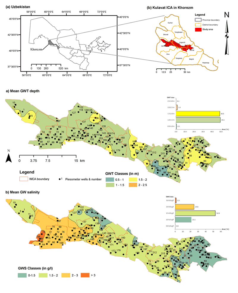
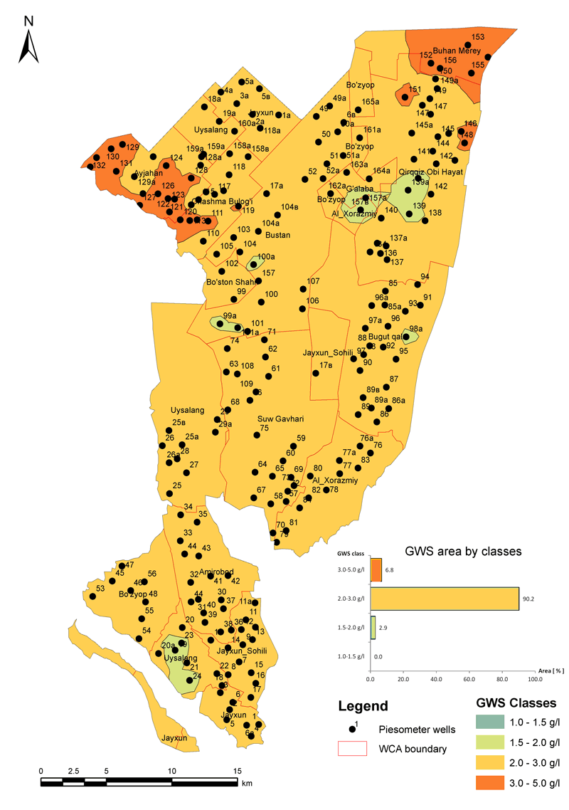
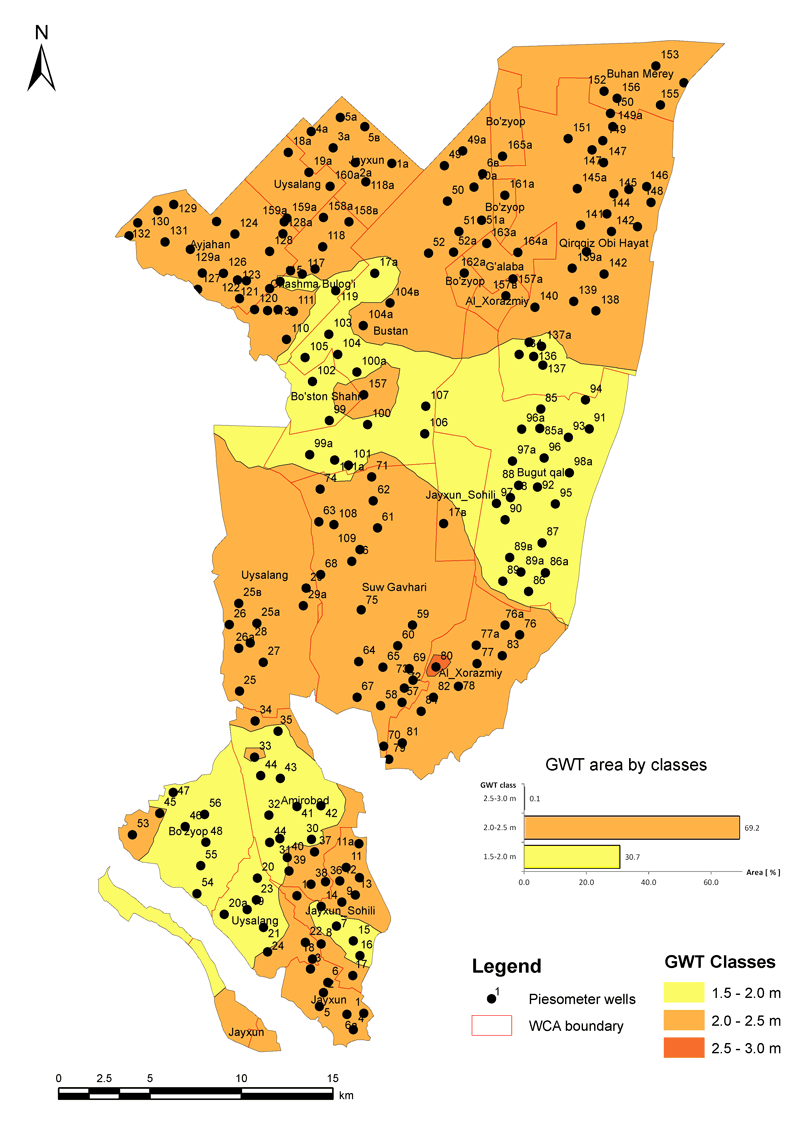
Average vegetation period groundwater table (GWT) and salinity (GWS) in Kulavat
Irrigation and drainage network in Ellikkala
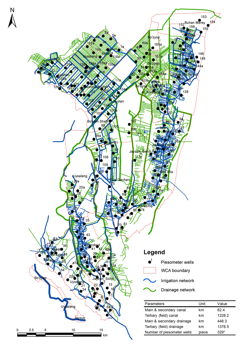
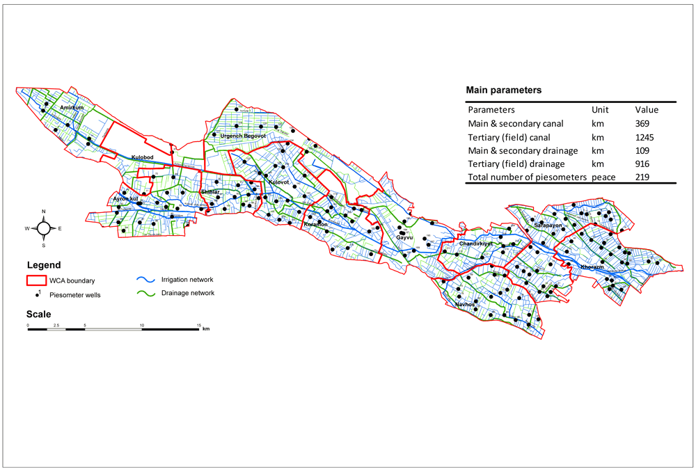
Irrigation and drainage network in “Kulavat” ICA
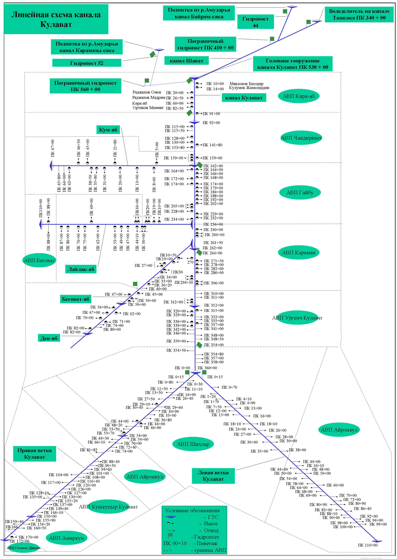
Linear scheme of kanal Kulavat
Mean annual (2005-2010) groundwater salinity in Ellikkala
Mean annual (2007-2009) groundwater table in Ellikkala
Monographs
Papers
Reports
Annual report 2015 for WP6 (Sh.Muminov, A.Khaliullina)
Handbooks
Kenjabaev Sh. - Handbook for in-situ sampling and field observation