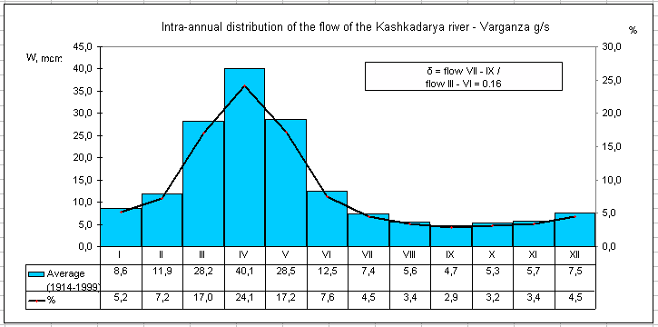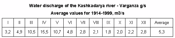

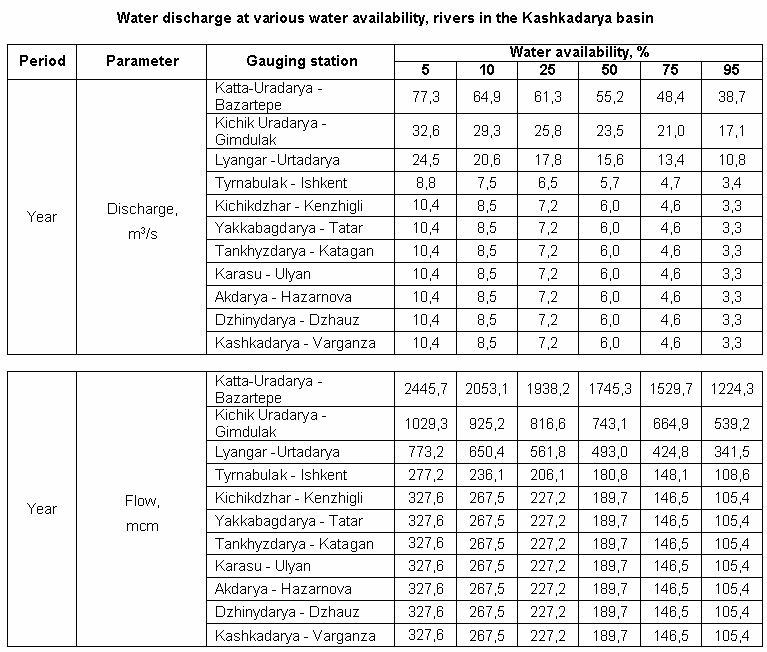
Basin hydrology
The Katta-Uradarya River flows in the Kamashi and Dekhkanabad districts of the Karshi province (Uzbekistan). It is a right tributary of the Guzardarya River. In the upper reaches, it is called Igrisu or Chimbay, according to some sources, in the middle reaches – Aksu, and in the lower reaches – Igrisu.
Large tributaries of the Katta-Uradarya are Almatsay (right), Kyzylsay (left), Gaukhana and Zarangbulak (left), and Shorsu.
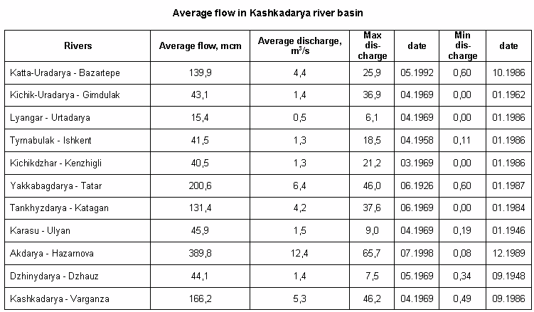
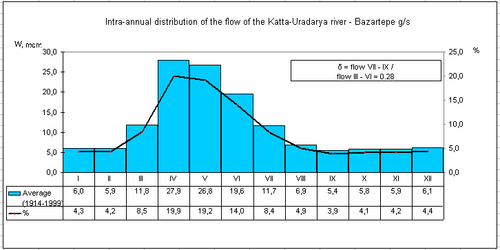
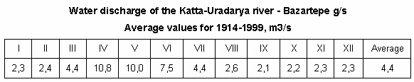
The length of the Katta-Uradarya River is 113 km, and basin area is 1,410 km2. Average multi-year water discharge, as measured in the Bazartepa village, amounted to 4.81 m3/s, with the runoff variability ratio of 0.476 (over the observation period of 1965-2002). The river is fed by snow, rain, and spring waters. High-water period is observed in March-May. In the Bazartepa village, annual water volume is 151.8 mcm; flow average modulus is 3.85 l/s km2; depth of runoff is 121 cm/year.
The Katta-Uradarya originates in the western part of the Gissar range, from the Kharkush pass (3,448 m). According to the National Encyclopedia of Uzbekistan, the river is called Igrisu in the head. According to the topographic maps of the General Staff, the river acquires the name of the Igrisu River downstream of the head, approximately in the similarly-named village, and it is called Chimbai in the head and then Aksu.
In a small area in the upper reaches, it flows northeast, further upstream of the Dukankhana village, and then it flows westward and south up to the mouth (but the channel forms many bends). Katta-Uradarya flows mainly through mountains.
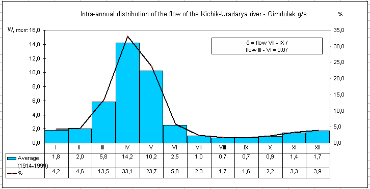
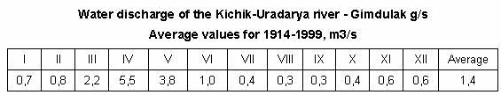
The Guzardarya River is formed by the confluence of the Katta-Uradarya River, on the right, and the Kichik-Uradarya River, on the left. The Pachkamar reservoir is built at the confluence of these rivers. Beyond the Ravat settlement, the Katta-Uradarya River flows into the northeastern section of the reservoir at an altitude of 670 m.
At the Supa village (Igrisu section), the flow velocity amounts to 3 m/s, 1.2 m/s at the Alma village, 2 m/s at the Abad village, and 0.8 m/s at the Ravat settlement, near the mouth. At the Bakyrchi village, the width of the river is 8 m, and the depth is 1 m; at the Kan village, these values amount to 16 m and 50 cm, respectively; at the Nayman settlement — 12 m and 50 cm, respectively; at the Baytkurgan settlement – 20 m and 60 cm, respectively; at the Abad settlement — 10 m and 50 cm, respectively. The nature of bed river is hard.
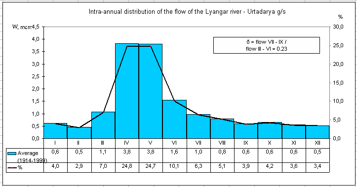
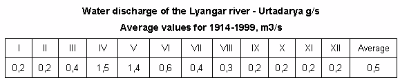
The Lyangar River flows in the Kamashi district of the Kashkadarya province (Uzbekistan). In the past, it was the left tributary of the Kashkadarya River.
The length of the river is 76 km; basin area is 258 km?. The river is fed by snow and rain. Average multi-year water discharge is 0.9 m3/s. Maximum water discharge is observed in April and May. Intensive mudflows occur in spring.
The Lyangar River originates in the Gissar moutains – in the Yakkabag range at an altitude of 2,200-2,300 m. In the head, it flows westward. In the upper reaches, the river forms a narrow and deep valley and passes through the Kurekdara Gorge. Near the Yakkaarcha village, it turns northwest. In the Langar village, the river valley expands. Beyond the reservoir dam, the river again flows westward. In summer, due to water withdrawal for irrigation, the Lyangar River does not reach Kashkadarya.
The Yakkabagdarya River flows in the Kamashi, Yakkabag, and Shakhrisabz (end of the Kzylsu section) districts of the Kashkadarya province (Uzbekistan).
In the upper reaches, it is called Irgaylik, in the middle reaches – Sarytukay, and in the lower reaches – Kyzyldarya or Kyzylsu. Then the river is divided into two sections: Yakkabagdarya (or Kyzylsu) in the northwest and Karabagdarya in the west. Kyzylsu is the left tributary of the Tankhizydarya.
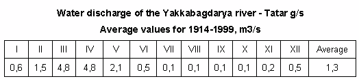
The length of the Yakkabagdarya is 99 km. The basin area is 1,180 km2, of which 755 km? accounts for catchment area. The river is mainly fed by snow and glaciers. In the upper reaches, it is fed by spring waters as well. Average multi-year water discharge, as measured at the Tatar village (50 km away from the head, area of the upper catchment basin is 514 km? at an average altitude of 2,730 m) amounts to 6.11 m3/s. At this point, annual runoff volume is 192.6 mcm; average flow modulus is 12.1 l/s km2; the depth of runoff is 382 cm/year; the runoff variability ratio is 0.444 (over observation period of 1930-2002).
Variations of water discharge by year are typical for the Yakkabagdarya. Average annual indicators vary between 2.15 m3/s (low-water years) and 12.6 m3/s (high-water years). High-water period is from March to August, with the bulk of runoff formed by snow and glaciers in May-July. The highest daily water discharge is in May and June (up to 72.1 m3/s in high-water years and 17 m3/s in low-water years); floods occur at the end of May. In July-August, high water of the Yakkabagdarya decreases to 1-3 m3/s. The lowest water discharge is from December to March.
At the Suvlisai settlement, the river is 13 m wide, 70 cm deep, with flow velocity of 2.5 m/s; near the Beshkapa settlement, the width is 40 m and the depth is 1.4 m; near the Chigatai settlement, these figures amount to 20 m and 1.5 m, respectively, with flow velocity of 1.7 m/s. Upstream of the confluence point, the width of the Yakkabagdarya (Kzylsu) channel is 18 m, depth – 30 cm, and flow velocity – 0.4 m/s. The nature of river bed is rocky.
Irgaylik originates on the western slope of the Gissar range; its sources lie west of Khojapiriya point, at the border of the Kashkadarya province with Surkhandarya province. The river is formed by glaciers at an altitude of 3,949 m.
From its head, the river flows northwards, then gradually turns westwards and flows westwards (with some slope and bends to the north or south in some areas). At the Gissar Reserve, the river changes its name consistently: at the Ustanulgan mountain area, it is called Saritugai, lower, south-west of the Kyzylmechet mountain area, it is already called Kyzyldarya. The Kyzyldarya literally means "Red River". It is related to the color of the water, which contains red clay (in the form of an admixture and in a suspended state) in summer.
Downstream of the Tashkurgan, the Kyzyldarya River turns northward flowing between the rocks on both sides of the cliffs. The northern direction, which had only a certain slope to the west, is gradually being replaced by the north-western direction and then by the western direction. In the Eski-Yakkabaga district, the river flows out of the mountainous area and is dissected.
In the Eski Yakkabag village, the river is divided into two channels. The first channel flowing to northwest is called Kzylsu or Yakkabagdarya. The other flows westward and is called Karabagdarya. In this section, water is used for irrigation needs; the right-bank and left-bank canals originate from the Yakkabag hydroscheme on the Yakkabagdarya River.
To ensure optimization of water withdrawal for irrigation canals, the Yakkabag hydroscheme was constructed on the Yakkabagdarya River. Two distributing canals embed in concrete originate from this hydroscheme – right-bank canal with water discharge of 5 m3/s and left-bank canal with water discharge of 20 m3/s (in the Eski-Yakkabag district, downstream of the dissection point). This set of facilities substitutes the former diversion facilities set at the river itself. Upstream of the Kyzyldarya, small diversion facilities are installed, with average water discharge of not less than 3 m3/s. Their total length is 14 km. Seepage-control lining of canals is applied for the Yakkabagdarya facilities.
The river supplies water to the Karabag reservoir (built on the Karabagdarya) and Kamashi reservoir (it is filled through mudflows and floods in April-June).
On the territory of the Gissar Reserve, permanent and quite large tributaries flow into the river: Kalasai, Dong-Dong-Chokan (Dondonchokan), Shilkhozor (Shalkhazar), Kattahursan (Katta-Khursan), Karankul, Aksu, Koltyksai and Kichikkalasai. In addition, various spring streams join the river in the upper reaches of the river.
In the lower reaches, there are intermittent tributaries – right tributary Karankalsay (near Khaydarbulak) and left tributary Buvashady (near Eski-Yakkabag). The largest left tributary Tyrna is merged with the Kyzyldarya beyond the Chunchakay village. After the dissection, only the Karabagdarya River receives rivers, which dry up in the lower reaches (the Taldy River flows in downstream of the Karabag reservoir; moreover, the Guldara River hardly reaches it).

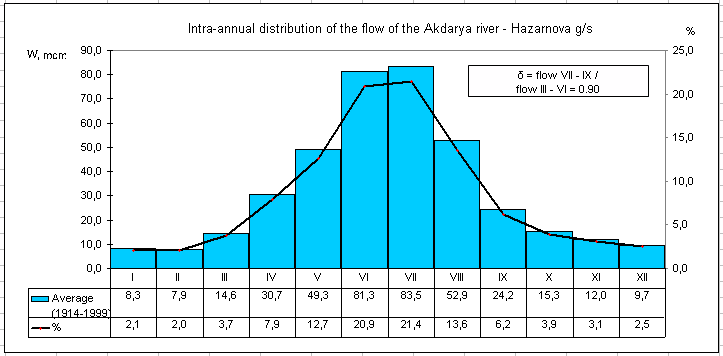
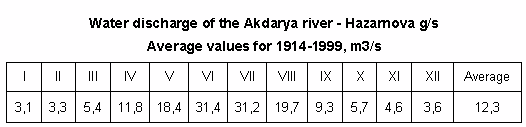
The Akdarya River (Aksu in the upper reaches) flows in the Kashkadarya province in Uzbekistan. The length of the river is 154 km, and the basin area is1.280 km?. The river originates on the slopes of the Gissar Range and flows into the Kashkadarya River. It is fed by snow and glaciers. High-water period is observed from May to September, with maximum water discharge in May-June. The average water discharge is12.3 m3/s (near the Khazarnov village). Downstream of that point, water is diverted for irrigation. The average discharge of suspended load is 12 kg/s. In the lower reaches, the river dries up; the channel becomes overgrown. Water composition is of hydrocarbonate-calcium nature, with average salinity of 200-240 mg/l.
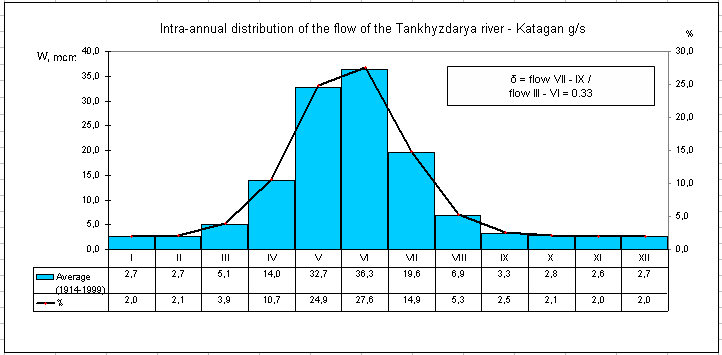
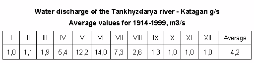
The Tankhizydarya River flows in the shakhrisabz and Chirakchi districts in the Kashkadarya province, Uzbekistan. The length of the river is 93 km, and the basin area is 1,910 km?, from the Nushkent village at the river mouth (the catchment area is 425 km? upstream of the Kattagan; this figure may be shown as the total basin area). Variations in average annual water discharge are typical for the Tankhizydarya River: water discharge reaches10.1 m3/s in high-water years and decreases to 1.67 m3/s in low-water years. In Nushkent, average multi-year water discharge amounted to 5.46 m3/s, given the runoff variability ration of 0.563 (over 35 years of observations in 1930—1974). The river is fed by snow, rain, and partially by glaciers. High-water period is from March to June; water volume decreases from mid-summer.
The Tankhizydarya River originates on the western slope of the Gissar Range, flowing from the high-mountain lake Kichikgozi at an altitude of 3,900 m. It passes westward through the territory of Shakhrisabz district. About 70 km of the river falls on the mountains. In the lower reaches, it flows along the southern outskirts of Shakhrisabz. It flows into the Kashkadarya River near the village of Nushkent, entering the Chirakchinsky district. The tributary of the Tankhizydarya is the Yakkabagdarya River (Kzylsu branch on the left).
The mountainous Djinnidarya River flows in the Kitab district in the Kashkadarya province, Uzbekistan. It is the left tributary of the Kashkadarya River. In the upper reaches, it is called Zugatasay.
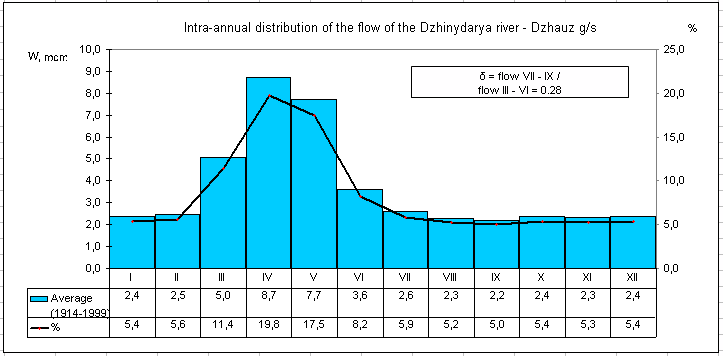
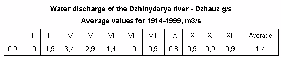
The length of Djinnidarya is 57 km, and the catchment area is 367 km?. The river is fed by the mix of snow, rain and spring water, as well as groundwater, according to some sources. High-water period is from March to June, for which 56% of the annual runoff accounts. However, high water discharge is observed in April, with the average value of 3.30 m3 /s. Low-water period is in August and September. The average annual water discharge, as measured in the Javuz village, is 1.35 m3/s. During spring heavy rains, medium and heavy mudflows are also observed in the river channel and its tributaries, when water discharge of 46.2 m3/s was recorded (March 26, 1970). The river is 2.0 m wide before the confluence, 30 cm deep, with stony bottom.
The Djinnidarya River originates at the junction of the Zarafshan and Gissar ranges, at an altitude of about 2,500 m, receiving water from 100 sources flowing down from the western slope of Sherdag Mountain. It mainly flows westward; in flows north in upper reaches; the river flows south in the middle reaches. Bends are formed in the lower reaches. Near the Beshkaltak settlement, it flows into the Kashkadarya River.