

Land resources of the Aral Sea basin
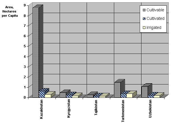
In Central Asia agricultural farming has always been the main sphere of employment for the rural population. Today farming still employs about 60% of the rural population, hence it is of fundamental importance for their well-being. The prosperity of Central Asia, as an agrarian region from ancient times, was always very closely interrelated with land use. From this point of view the fertile soils formed the framework for prosperity for the working population. Out of the total land resources of about 154.9 million hectares some 59.1 million hectares are considered as cultivable, of which only about 10 million hectares are actually used. Half of the actually cultivated lands are located in the oasis’s (they are naturally drained, with fertile soils). The other half of the land requires for their use a complicated and expensive set of reclamative measures, including not only drainage and leveling, but also improvement of soil structure. Distribution of lands among the countries shows a big inequity, characterized by good land availability in Kazakhstan and Turkmenistan and land scarcity for the three other countries.
Land resources per capita in the countries within Aral Sea basin
Figire shows this inequity, which causes a “land deficit” in Tajikistan and Kyrgyz Republic and in some zones of Uzbekistan, such as Khorezm, Fergana Valley and Samarkand provinces. This situation, plus scarcity of water, is a basis for friction between states, provinces, tribes and even local societies. The significance of the former large-scale developments of new desert areas in the Soviet times, such as Golodnaya Steppe, Karshi Steppe, areas along the Karacum Canal, Asht and Lylak systems, was that they allowed the resettlement of hundreds of thousands of people from the more populated areas. Such enormous undertakings are no longer a viable option for the post Soviet independent and economically weak countries. Thus decision should be based only on the improvement of the available resources not major new developments.
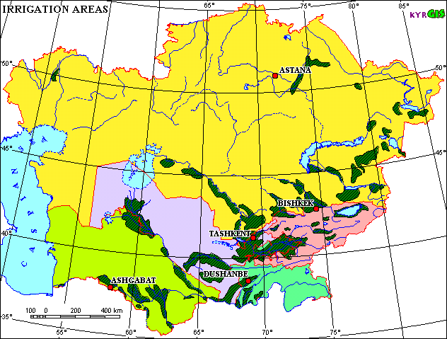
Irrigated lands
Out of the total land resources of about 154.9 million hectares some 32.6 million hectares are considered suitable for irrigation, while only about 7.9 million hectares are irrigated (or only 5.1% of total territory of the Aral Sea basin). The non-irrigated area (pastures, hay, meadows, long-term fallow land) occupy about 54 million hectares. This area includes some 2 million hectares of rain-fed arable land but its productivity is on average no more than one-tenth of the productivity of irrigated land. At the moment, the rain-fed land does not play any significant role in the total agricultural production in the Aral Sea basin, with the exception of extensive system (semi-nomadic) livestock husbandry (cattle and sheep). Nonetheless, raising productivity of non-irrigated (rain fed) lands is an important goal. Some crops (e.g. grains), which at the moment are being increasingly grown in the irrigated areas, could be moved to non-irrigated areas thus reducing substantially the volume of irrigation water withdrawn in the basin.
Since independence, the area of irrigated land has not changed significantly in the Central Asian states (with the exception of Turkmenistan where the area of irrigated land during 1995-1996 increased by about 400,000 hectares). However, there have been big changes in crop patterns. Cotton still remains one of the most important crops, although between 1990 and 1998 its share of irrigated agriculture decreased from 45 % to 25 %. In the same period, the area under cereals (wheat, rice, maize and others) increased from 12 % to 77 %. Wheat became the dominant crop in the region, which covers about 28% of total irrigated area. Fodder crops in 1998 occupied only 19.6 % of the total irrigated area, compared to 27,4% in 1990, what is highly undesirable from the point of view of maintaining soil fertility and crop rotation. For a wide variety of reasons, including the high cost of inputs (especially gasoline and chemical fertilizers) and disrupted markets, the levels of both yields and production of major crops (cotton, cereals, maize) in irrigated farming have decreased by 5% to 30% in every country since 1990.
The large-scale irrigated farming in Central Asia is based on a well developed system of irrigation and drainage facilities, including unique projects such as Karshi where pumping stations with a total capacity of 350 m3/sec lift water for 180 m and several large-scale gravity irrigation systems with the mean annual water supply of individual systems approximating up to 700 m3/sec. By the end of 1998, the overall length of main and inter-farm irrigation networks in the Basin was 47,750 km. Of this, about 28% have anti-filtration linings. About 77% of farm intakes are equipped with flow gauges. On-farm irrigation networks total 268,500 km; about 21% of this length has anti-filtration lining. The remaining on-farm canal length has unlined earth beds. Since 1990, on-farm irrigation networks have deteriorated due to the poor financial situation of both state-owned and privatized farms which have no possibilities either to reconstruct on-farm networks or maintain them in a satisfactory condition.
Although during the last ten years specific water consumption in the Basin has been gradually decreasing due to limits on water intake imposed by interstate organizations (1980 - 18,200 m3/ha, 1990 - 14,600 m3/ha, 1995 - 12,200 m3/ha, and 1998- 12,400 m3/ha), this reduction has not been accompanied by an improvement of the technical conditions of the systems and introduction of advanced irrigation techniques due to lack of funds and insolvency of water consumers. There is also a great difference between the actual and required water consumption. While calculated irrigation rates ranged between 3,800 m3/ha to 11,200 m3/ha, actual specific water consumption in 1990-1998 was from 4,500 m3/ha to 20,600 m3/ha. At the same time, it is a priority to consider introduction of local irrigation methods (drip, sprinkling, dispersion) in areas with steep slopes and on mountain foothills where these methods will reduce irrigation water consumption by 2 to 3 times, preventing at the same time undesirable environmental effects (waterlogging due to infiltration of more than
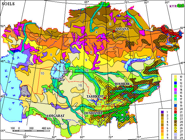
1 Leached and Podzolized Chernozems 2 Usual Chernozems 3 Southern Chernozems 4 Dark - Chestnut and Chestnut Soils 5 Association of Dark- Chestnut and Chestnut Soils with Solonetzs 6 Light - Chestnut often Solonetz-Like Soils 7 Association of Light -Chestnut Soils with Solonetzs 8 Brown Semidesert often Solonetz-Like Soils 9 Association of Brown Semidesert Soils with Solonetzs 10 Association of Brown Semidesert Soils 11 Sierozems on the Sizeable Areas Transformed by the Irrigation 12 Bog Soils 13 Associations and Combinations of Meadow - Chernozem Soils, Solonetzs and Solods 14 Soil Associations with Solonetzs Predominance 15 Solonchaks often in Combination with Solonetzs 16 Combinations of Takyr Soils and Takyrs 17 Alluvial Soils and Meadow Soils 18 Sands and Weak Developed Sand Soils 19 Mountain Tundra Soils 20 Mountain Podzolic Acid Unpodzoled Soils 21 Mountain Gray Forest Soils 22 Mountain Meadow Soils 23 Mountain Meadow - Steppe Soils 24 Mountain Chernozems and Mountain Chestnut Soils 25 Mountain Cinnamon and Mountain Gray - Cinnamon Soils 26 Mountain Sierozems 27 High Mountain Desert Soils 28 Glaciers 29 Areas Appeared Due to Shrinkage of Caspian and Aral Seas
Salinization and drainage
Peculiarities of the climatic and hydro-geological conditions make soil particularly vulnerable to salinisation in Central Asia. Some lands, especially in inter-mountain valleys, are initially salt affected due to the actions of climate aridity. The process of salt accumulation is intensified under the influence of pressure form deep saline artesian water and the following two factors:
(a) additional infiltration of irrigation water to drainage network,
(b) deterioration of downstream water quality.
This is due to natural evaporation processes and the use of overly saline irrigation water (approximately on 1.2 million hectares) as well as because of naturally poor land drainage conditions (almost 4 million hectares). Out of the total net irrigated area of about 7.9 million ha in the Aral Sea Basin, over 5 million ha requires man-made drainage, and about 4.5 million ha is provided with such drainage. Actually 56.8% of the irrigated area (or 4,513,253 ha) has drainage. Out of total drainage, about 59.6% is surface drainage, 26.2% - sub-surface, and 14.2% is vertical drainage (tube-wells).
All this has affected the state of irrigated lands characterized by high groundwater tables and extent of salinity. The area with high groundwater levels (less than 2 meters below the surface) increased in the years 1990-1998 from 25% to 34% of the total irrigated land. In the same period, the area of moderately and strongly-saline land (where crop yields are reduced by 20% to 50%) increased from 23.4% to 28.5% of the total irrigated land. About 60 % of irrigated land in the Aral Sea Basin is classified as non-saline, according to the Central Asian standards (the main criteria is the total amount of toxic salts in the soil). This may in the future result in a drastic loss of land productivity due to a wide spread of soil salinity.