
Location, geomorphology, landscape
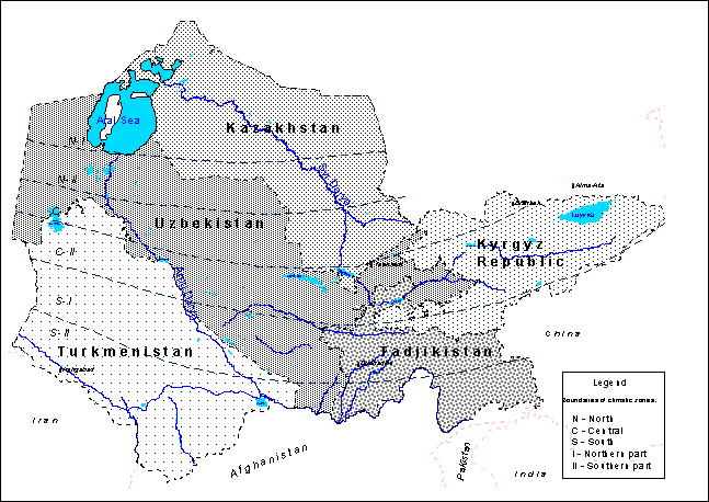
The Aral Sea basin, which geographically coincides with almost the entire area of Central Asia, is located in the heart of the Euro-Asian continent. More specifically, the Aral Sea basin covers the whole territory of Tadjikistan, Uzbekistan, the majority of Turkmenistan, three provinces of the Kyrgyz Republic (Osh, Jalalabad and Naryn), and the southern part of Kazakhstan (two provinces: Kyzyl-Orda and South Kazakh), and northern part of Afghanistan and Iran. For the purpose of this presentation, only the provinces of the first five countries within the Aral Sea Basin have been taken into consideration. This territory extends between longitudes 56o and 78o East, and latitudes 33o and 52o North, covering an area of about 1.549 million km2, of which about 0.59 million km2 are cultivable lands.
Land resources in the Aral Sea basin
Country |
Area of the country |
Cultivable area |
Cultivated area | Actually irrigated area |
|
ha |
ha |
ha |
ha |
|
|
Kazakhstan* |
34 440 000 |
23 872 400 |
1 658 800 |
786 200 |
|
Kyrgyzstan* |
12 490 000 |
1 257 400 |
595 000 |
422 000 |
|
Tajikistan |
14 310 000 |
1 571 000 |
769 900 |
719 000 |
|
Turkmenistan |
48 810 000 |
7 013 000 |
1 805 300 |
1 735 000 |
|
Uzbekistan |
44 884 000 |
25 447 700 |
5 207 800 |
4 233 400 |
|
The Aral Sea basin |
154 934 000 |
59 161 500 |
10 036 800 |
7 895 600 |
|
* only provinces in the Aral Sea basin are included |
||||
The territory of the Aral Sea Basin can be divided into two main zones: the Turan plain and the mountain zone. The Kara Kum covers the western and the northwestern parts of the Aral Sea Basin within the Turan plain and Kyzyl Kum deserts. The eastern and south-eastern parts are situated in the high mountain area of the Tien Shan and Pamir ranges. The remaining part of the basin is composed of various types of alluvial and inter-mountain valleys, dry and semi-dry steppe. Different forms of relief in all the countries have created specific conditions, which are reflected by the interrelation between water, land and populated area within the region. About 90% of the territory of the Kyrgyz Republic and Tajikistan are occupied by mountains. This, on the one hand, creates for these two countries a "monopoly" on the formation of water within the basin and, on the other hand, a deficit of cultivable lands. The most important feature of the region is the number of oasises (Fergana Valley, Khorezm, Tashaus, Mary, Zerafshan, Tashkent – Chimkent), which cover a small part of the overall area, but since ancient times have been the focus of human activity and population due to the presence of acceptable living conditions (water, precipitation, the best soils, etc).
The majority of the territory of Kazakhstan, Turkmenistan and Uzbekistan are covered by desert (more than 50%), and only less than 10% is represents by mountains. Such distribution of area has created a huge potential for the development of irrigation, which requires more water resources than those countries have available. This unequal allocation of water and land were seen in Soviet times as an opportunity to re-allocate the water resources for the development of newly irrigated area in lowland republics. However, in the current post Soviet period these circumstances have been transformed into a source of potential future conflicts.
Climate
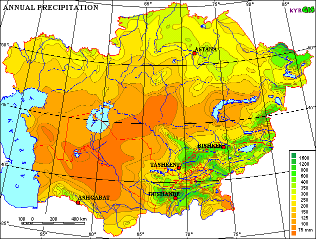
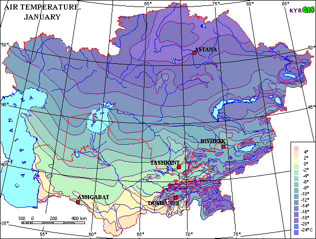
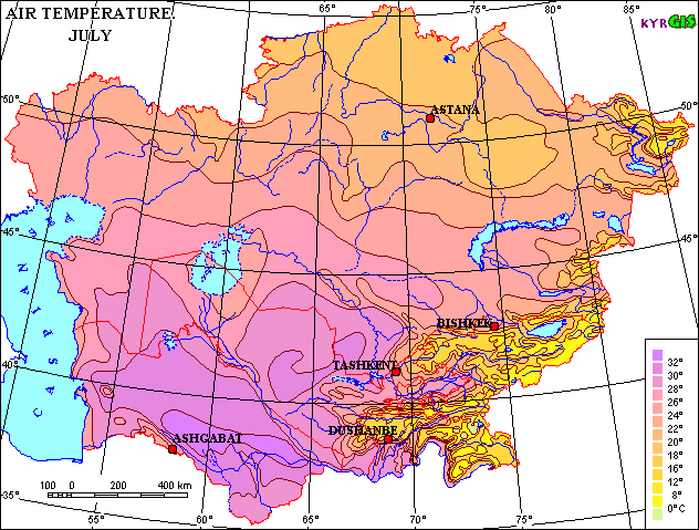
The landlocked position of Central Asia within the Euro-Asian continent determines its sharply continental climate, with low and irregular precipitation. Large daily and seasonal temperature differences are characteristic of the region, with high solar radiation and relatively low humidity. Diverse terrain and altitude differences from 0 to 7,500 m above sea level lead to a great diversity of microclimate. Mountains are located in the east and southeast, which are the center for the formation of water and the origin of its flow. Although this area is often struck by humid winds, the mountains trap most of the moisture, leaving little precipitation for the other areas of the Aral Sea Basin.
The average July temperature on the lower elevations, in valley areas and desert, deviates from 26oC in the north to 30oC in the south, with maximum temperature up to 45-50oC. The average January temperature records are up to 0oC in the south to -8oC in the north with absolute minimum up to -38oC. The annual precipitation in the lowland and valleys is between 80-200 mm, concentrated in the winter and spring, while in the foothills precipitation is between 300-400 mm, and on the southern and south-western sides of the mountain ranges between 600-800 mm.
Climate in the region has specific zones of variation accordingly to geographic and geomorphologic conditions, which define the difference in water demands for irrigation. Big differences in air humidity in summer time between the old oasises and newly irrigated area (50-60% and 20-30%) cause significantly larger water demands in former desert (now under irrigation) in comparison with oasis’s. The second factor especially affecting agricultural production is the instability of spring weather, which deviates in temperature, precipitation and even late frosts (sometimes in the beginning of May) and hail (in June, which sometimes destroys emerging cotton plants and vegetables over big areas).
Scheme of the Climatic Zones in the Aral Sea basin
Characteristics of the Climatic Zones
|
Climatic Zones |
Evaporation, m3/ha |
Precipitation, m3/ha |
Average temperature, oC |
|
|
January |
July |
|||
|
N-I |
400 |
500 ... >3000 |
- 7.39 |
27.61 |
|
N-II |
600 |
500 ... >3000 |
- 4.58 |
28.27 |
|
C-I |
1000 |
600 ... >3000 |
-0.94 |
29.0 |
|
C-II |
1200 |
700 ... >3000 |
0.59 |
26.57 |
|
S-I |
1400 |
900 ... >3000 |
2.86 |
29.21 |
|
S-II |
1600 |
1000 ... >3000 |
2.29 |
29.5 |