

Water Resources Management in Afghanistan: The Issues and Options
Surface Water Resources
Although Afghanistan is located in half deserted atmosphere, it is still rich in water resources mainly due to the series of high mountains such as Wakhan, Hindokush and Baba covered by snow. Over 80 per cent of the country’s water resources have their origin in the Hindu Kush mountain ranges at altitudes above 2,000 m which function as a natural storage of water in form of snow during winter and thus support perennial flow in all major rivers by snow melt during summer.
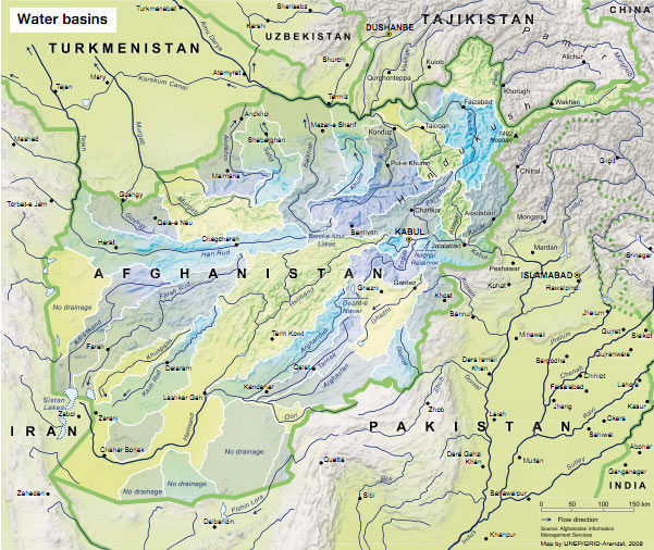
Afghanistan is part of 3 large river basins: The Amu Darya basin in the North separated by the Hindu Kush mountain range from the Desert basin in the South, and the Indus basin in the East. Because of practical reasons related to the quantification of available surface water volumes, the hydrological classification is based on principal watershed units. Based on the hydrological and morphological systems, the country can be divided into four main river basins. General characteristics of these four river basins are shown in Table.
General Characteristics of four river basins of Afghanistan
| River basin | Rivers included in this basin | Catchment area (Km2) | Storage capacity (Billion m3) |
| Amu Darya basin | Wakhan, Kokcha, Kundz, Pamir/Panj, Marghab, Shrin Tagab, Sur pul, Bulkh, Kashan, Kushk, Gulran | 302 000 | 24 |
| Helmand river basin | Helmand, Arghandab, Ghazni, Trank, Arghastan, Musa Qala | 218 600 | 6.5 |
| Western rivers basin | Khash, Farharod, Aderskan, Harierod etc | 85 300 | 2.5 |
| Kabul/Indus basin | Kabul, Kunar, Alishing, Alinegar, Logar, Pangshir, Shutol, Ghorbund, Laghman, Maidan | 72 000 | 22 |
| Total | 55 | ||
Recent estimates indicate that the country has 75 billion cubic meters (BCM) of potential water resources of which 55 BCM is surface water and 20 BCM is groundwater. The annual volume of water used for irrigation is estimated to be 20 BCM, which is 99 per cent of all water used. Total groundwater extraction amounts to some 3 BCM. Approximately 15 per cent of the total water volume used annually originates from alluvial groundwater aquifers (9 per cent) and springs (7 per cent), and almost 85 per cent from rivers and streams. Ground water used from deep wells counts for less than 0.5 per cent. The annual per capita water availability is approximately 2500 cubic meter, which compares favorably with other countries of the region, for example, with Iran (1400 cubic meter per capita per year) and Pakistan (1200 cubic meter per capita per year). A qualitative assessment shows that Afghanistan's water resources are still largely underused which is supported by the data presented in Table:
Estimated Surface and Ground Water Balance (BCM per year)
| Water Resources | Potential | Present use | Balance | Future use* | Balance |
| Surface Water | 57 | 17 | 40 | 30 | 27 |
| Groundwater | 18 | 3 | 15 | 5 | 13 |
| Total | 75 | 20 | 55 | 35 | 40 |
* All existing irrigation schemes rehabilitated and managed efficiently
It is not clear, however, how much of this ‘potential’ resource can be accessed without damage to people and ecosystem. For example, how much of the groundwater can be extracted without leading to an excessive decline in groundwater levels and reaching to a stage of ‘water mining’.
There are plenty of individual discharge data of many of Afghanistan's rivers, particularly from the Kabul and the Helmand rivers as well as from their tributaries. However, no reliable documentation is available about the systematic quantification of surface water resources at watershed level. In Table, an attempt is made to quantify the annual surface water resources at watershed level. The limited reliability of data collected did not allow presenting the surface water resources potential at regional level. Most of the rivers listed in the table are perennial although many of them fall dry at their lower reaches during late summer due to the diversion of water for irrigation purposes. Discharges are rising continuously from March onward caused by snowmelt culminating in June/July before receding to a minimum in Dec./Jan. Most disastrous floods occur after heavy rainfall in March/April, especially when snowmelt is already well advanced.
Surface water quality is excellent in the upper basins of all rivers throughout the year and good in the lower basins in spite of large irrigated areas. As far as it is known, the presence of saline soils in irrigated areas is never caused by poor water quality but rather by over-irrigation (water logging) or lack of irrigation water (fallow fields and high ground water table).
Estimated Surface Water Potential
| Name of River Basin | Drainage Area (km²) |
Mean Ann. Vol. (mln m³) |
| AMU DARYA BASIN | ||
| North-eastern river basins | ||
| Panj | 27 800 (+ 29 000 in Tajikistan) | 36 420 |
| Kokcha | 21 100 | 5700 |
| Kunduz | 37 100 | 6000 |
| Total | 86 000 (+ 29 000 in Tajikistan) | 48 120 |
| Northern river basins | ||
| Murghab | 26 200 | 1350 |
| Kashan, Kushk, Gulran | 12 200 | 110 |
| Samangan (Khulm) | 8300 | 60 |
| Balkhab | 19 300 | 1650 |
| Saripul | 10 800 | 40 |
| Shirin Tagab | 12 100 | 100 |
| Amu Darya deserts | 27 100 | 30 |
| Total | 116 000 | 3340 |
| Hari river (Harirud) basin | 39 000 | 1600 |
| DESERT BASIN | ||
| South-western river basins | ||
| Farah | 27 800 | 1250 |
| Harut (Adraskan) | 23 800 | 210 |
| Gulistan (Bakwa desert) | 9100 | 40 |
| Khash | 10 500 | 170 |
| Kajrud | 20 800 | 60 |
| Total | 92 000 | 1730 |
| Helmand river basin | ||
| Ghazni | 19 200 | 350 |
| Helmand at Kajakai dam | 42 200 | 6000 |
| Musa Qala | 3700 | 220 |
| Arghandab | 53 000 | 820 |
| Lower Helmand | 47 900 | 110 |
| Total | 166 000 | 7500 |
| Southern river basins | 70 000 | 70 |
| INDUS BASIN | ||
| South-eastern river basins | ||
| Gomal | 10 700 | 350 |
| Margo, Shamal, Kurm | 400 | |
| Total | 19 000 | 750 |
| Kabul river basin | ||
| Panjir | 11 000 | 3130 |
| Kunar | 13 000 (+ 14 000 in Pakistan) | 15250 |
| Kabul (without Panjir & Kunar) | 30 000 | 2540 |
| Total | 54 000 (+ 14 000 in Pakistan) | 20 920 |
| TOTAL | 642 000 | 84 000 |
Source: Water Resources Management in Afghanistan: The Issues and Options by Asad Sarwar Qureshi, IWMI, Working Paper 49