

Water Resources Management in Afghanistan: The Issues and Options
Climate
Afghanistan is characterized by a continental climate, although the presence of mountains causes many local variations. The typical climate varies from arid in the South and Southwest to semi-arid in most other parts of the country. The high mountain ranges of Hindu Kush and Pamir are moderate humid and covered by permanent snow and glaciers at altitudes above 5,000 m. With a few exceptions of some locations receiving sufficient rainfall in spring (Northern slopes of Hindu Kush above 1,000m altitude), the climate is not favorable for rainfed agriculture. During winter, temperatures are low and precipitation occurs in form of snow whereas during summer, temperatures are high and rainfall is virtually zero. Without irrigation supplies, these arid to semi arid areas cannot support any irrigation.
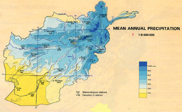
In Afghanistan, the water availability for irrigation purposes is mainly a function of effective rainfall and surface as well as groundwater resources - which depend in turn on the amount and distribution (time and space) of precipitation. Therefore, considering variations in precipitation as the most decisive parameter, Afghanistan can be divided into 6 climatic zones. The general features of these climatic zones are given in Table.
General features of 6 climatic zones of Afghanistan
| Zone | Name | Precip. (mm) | Dry (months) | Frost (months) |
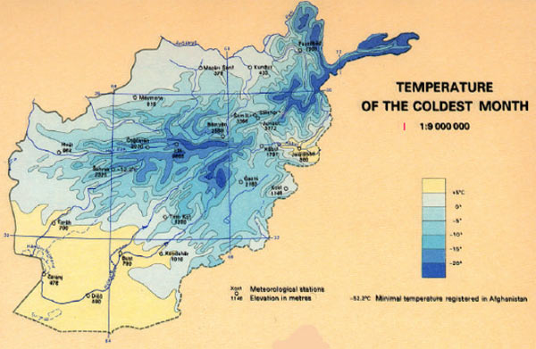
| 1 | Badakhshan (without Wakhan) | 300-800 | 2–6 | 1-9 |
| 2 | Central and Northern mountains | 200-600 | 2-9 | 0-8 |
| 3 | Eastern and Southern mountains | 100-700 | 2-9 | 0–10 |
| 4 | Wakhan corridor and Pamir | < 100-500 | 2-5 | 5-12 |
| 5 | Turkestan plains | < 100-400 | 5-8 | 0-2 |
| 6 | Western + South-western Lowlands | < 100-300 | 6-12 | 0-3 |
There is a strong relationship between the amount of precipitation, length of growing season and altitude. At greater altitudes, precipitation is high and the growing seasons are shorter due to frost hazard. In the mountainous zone of the country (zones 1-4) where precipitation is sufficient, the availability of agricultural land (due to frost) is a limiting factor. In the flat areas (zones 5-6), growing seasons are sufficiently long even for double cropping but the limiting factors are effective rainfall and irrigation water availability. .
Table presents the 12-year average records of precipitation, temperatures and evapotranspiration for19 meteorological stations located in 18 provinces. The annual distribution of precipitation (Table 3) shows the picture of an essentially arid country, with more than half of the area receiving 100 mm to 300 mm of precipitation. The remaining 50% of the country (having altitude of more 2000 m asl) receives 300 mm to 800 mm of precipitation. About 50% of the precipitation occurs in winter (January to March), much of which falls in the form of snow. A further 30% falls in spring (April to June) and the remaining 20% during summer and autumn.
Precipitation, temperatures and evapotranspiration at different locations of Afghanistan
| Location | Altitude [m asl] | Precipitation [mm/a] | Temperature [°C] | Annual ETP [mm/a] | Daily ETP [mm/d] |
| Shiberghan | 360 | 214 | -2-+38 | 1420 | 8 |
| Mazar-i Sharif | 378 | 190 | -2-+39 | 1530 | 9 |
| Kunduz | 433 | 349 | -2-+39 | 1390 | 8 |
| Baghlan | 510 | 271 | -2-+37 | 1100 | 6 |
| Jalalabad | 580 | 171 | +3-+41 | 1350 | 7 |
| Farah | 660 | 77 | 0-+42 | 1610 | 8 |
| Lashkargah | 780 | 89 | 0-+42 | 1720 | 8 |
| Maimana | 815 | 372 | -2-+35 | 1310 | 7 |
| Herat | 964 | 241 | -3-+36 | 1720 | 10 |
| Qandahar | 1010 | 158 | 0-+40 | 1790 | 10 |
| Khost | 1146 | 448 | -1-+35 | 1390 | 6 |
| Faizabad | 1200 | 521 | -5-+35 | 1020 | 6 |
| Qadis | 1280 | 323 | -3-+30 | 1240 | 6 |
| Jabul-Saraj | 1630 | 499 | 0-+31 | 1610 | 9 |
| Kabul | 1791 | 303 | -7-+32 | 1280 | 7 |
| Karizimir | 1905 | 433 | -7-+31 | 1100 | 6 |
| Ghalmin | 2070 | 222 | -8-+29 | 1100 | 6 |
| Ghazni | 2183 | 292 | -11-+31 | 1420 | 7 |
| Lal-Sarjangal | 2800 | 282 | -21-+25 | 950 | 5 |
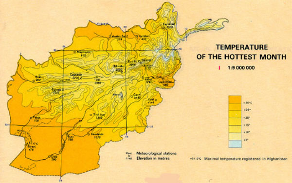
The daily (20°-30°C) and the seasonal (35°-40°C) variations of temperatures prevailing all over the country lead to different lengths of growing seasons, and require a careful selection of the most suitable crop for an area. This is reflected in many regions well known for their particular agricultural products (e.g. grapes, melons, rainfed wheat) or their natural forest cover (pistachio trees, pines). In the South-western desert plains, frost can occur in any month of the year even when temperatures reach a daily maximum of up to 40° C. Daily minimum temperatures in the Northern (Turkestan) plains can be as low as -20° C in winter and as high as +50° C in summer at one and the same location.
Annual evapotranspiration rates are relatively low in the Hindu Kush (1,000-1,300 mm) because of severe and long winters. They vary between 1,300 mm and 1,500 mm in the Northern plains and reach up to 1,800 mm in the Southern and Southwestern plains. However, summer evapotranspiration rates are high everywhere showing a daily peak of 6-8 mm in July/August. Due to strong winds occurring particularly in Mazar-i Sharif and Herat (bad-e sad-o bist ruz), maximum daily evapotranspiration rates are 9 mm and 10 mm, respectively.
Source: Water Resources Management in Afghanistan: The Issues and Options by Asad Sarwar Qureshi, IWMI, Working Paper 49
Source: GEOCART, “National Atlas of the Democratic Republic of Afghanistan", Warsaw, 1984