Summary of research project: |
Objective and technical fields:
Improvement of water use and management of soil water regimes and forecast of ground waters level rise in new irrigated lands. Objective of the work is to study the mechanism of water movement in aeration zone, the character of moistening and recharge by infiltration, the water-salt balance’s elements, ground waters regime and influence of irrigation on reclamation state of the developed and irrigated subsident virgin lands.
Scientific and technical approach:
New irrigated lands have technically improved irrigation systems, all intra-farm network consist of subsurface pipes or flumes, the main canals have anti-filtration lining. Water in distributive network of such system is not practically lost. Taking into account considerable irrigation depth and norm and non-observance of irrigation technique and technology, it can be expected that infiltration during irrigation will be an important factor in ground waters recharge and water-salt regime changes and will influence the reclamation state of irrigated and adjacent lands. Lack of data on relationship of infiltration and ground waters having thick aeration zone makes it difficult to foresee ground waters level rise and to develop measures on improving reclamation state of irrigated lands and adjacent territories-settlements.
Importance of the study: Development of measures on assessment of aeration zone and ground waters recharge by infiltration. Water-reclamation measures on increase of productivity of irrigated lands, irrigation water and water saving as well as proposals on obtaining planned productivity.
Environment characteristics:
Yavan valley is a tectonic hollow extended from north-east to south-west, its length is 76 km and it is from 1km (in upper reaches) to 15-17 km (in middle part) wide and formed by loess stratified rocks. Relief of the valley is slightly corrugated, height above sea level is 720 m in the south and 500 m in the north, maximum slope is 0,05 and more, minimum one is 0,008. Average annual air temperature is 16,8oC, maximum temperature is +30,8oC, minimum one is - 3,8oC. Frost-free period is 220 days. According to climatic and soil conditions the Yavan valley can be divided into two parts: first - north part(area is 6000 ha), second - middle and south part (area is 20000 ha). For the north part average long-term precipitation is 698 mm, maximum average annual precipitation is 920 mm, mainly in winter-spring period. Average annual evaporation is 1400 mm. In the south part of the valley annual precipitation is 250-400 mm, mainly in winter-spring period. Soils of the north part are brown-calcareous. Soil textural classes include heavy loam and clay. Volume weight increases with a depth from 1,4 to 1,62, in some cases up to 1,80 g/cm3, and permeability coefficient decreases from 0,2 m/day to 0,11 in top meter and 0,02 m/day in second and third meters. There are heavy salinized lands, type of salinity is sulphate magnesium-sodium. Ground waters are recharged by artesian waters at a depth of 0-5 m and by infiltration at the depth of 3-10 m. Due to recharge by artesian waters and natural weak drainability subsurface horizontal drainage was constructed on 5,3 th.ha of the north part before irrigation. Operation of horizontal drainage was observed by the Institute for Soil Science (M.A. Amindzjanov, 1969-1972).
Central and south parts of the valley are formed by sandy loam and loam. Total thickness of loess mounts to 80-90 m and more. Thickness of subsident layer in this part is 20-30 m and more. Up to a depth of 18-20 m density of dry soil varies within 1,20-1,36 g/cm3, porosity is 50-56%. Below 20m density increase from 1,36 to 1,60 g/cm3, porosity decreases from 49 to 43,5%. Natural moisture of top soils varies within 4-6%, below 20 m - 10-13%. Permeability coefficient up to 20 m varies from 1,0 to 0,1 m/day, up to 30 m is 0,1-0,08 m/day. Depth of ground water level increases from central axial part of the valley to foothills and from the north part to the south one (from 1-3 m to 40-60 m and more).
Hydraulic gradient is equal to 0,01-0,03. Waters are salinized and heavy salinized, their solid residue is 3-4 and 10-12 g/l and more. Salinity increases to the south. Type of ground waters is sulphate by anions and sodium-magnesium by cation.
Parameters of Pilot Projects and Technical Solutions:
Irrigated area of first developed lands was 6000 ha (1968), further, before 1972, 20000 ha (gross) were developed. Land use efficiency is 0,90. Six state farms were established, their specialization is cotton-growing and cattle-breeding. Water is supplied through tunnel into two big main canals (right and left line), then into machinery (P-1, P-2, P-3 and P-4) and flume canals. Total length is 210 km. Canals’ command zone is about 40 000 ha. Annual water discharge (outflow from tunnel) is more than 50 m3/sec. Efficiency of the main canal and distributaries is on the average 0,83 (efficiency of the system) in average.
Regime of ground waters was observed from 12 observation wells. Dynamics of soil moisture was studied also by 12 neutron moisture measuring wells placed beside observation wells (to a depth of 30 m). Studies on water duty, soil moisture dynamics, infiltration recharge of aeration zone, releases from irrigated fields and water balance were conducted in four main plots located in different parts of the valley (in the north, central and south parts of irrigated area).
Methodology:
Field studies of moisture dynamics during irrigation, water movement, water supply, infiltration recharge, intensity of moistening, water balance of aeration zone, ground waters and irrigated lands as a whole. Four main pilot plots were selected to conduct field observations of all the elements of water balance and ground waters regime. All the territory was equipped with wells for observations and for neutron moisture measuring. Moisture dynamics during irrigation was studied within 0-6 m horizon during 5 years by drilling and soil sampling. Moisture dynamics within 30 m was studied by neutron moisture meter. Dynamics of ground water level was studied by 12 observation wells placed beside wells for neutron moisture measuring. The results of field studies were analyzed using data of water related institutions. Field studies were conducted concurrently with laboratory studies on soil composition and characteristics within aeration zone using monoliths selected by digging a prospect-hole after each year of irrigation.
Results:
In order to assess and analyze the moisture dynamics within aeration zone, water balance and infiltration recharge the following water-physical constants were determined: moisture-holding capacity (MC), limit field capacity (FC) and capillary moisture (CM). They accounted for 35%, 22-24% and 12-14% of the dry soil weight respectively. In the control main plot (n 1) depth of water and irrigation norm were fixed. In the first irrigation year irrigation norm was 6-8 th. m3/ha. In the forth and fifth years irrigation norm was as planned 9-10 th. m3/ha. Quantity of waterings was 5-6. In other plots (n0 2,3 and 4) irrigation norms completely corresponded to farm water supply conditions. Their values were uneven and varied from 8 to 25 th. m3/ha, quantity of waterings was 2-3. Cotton productivity in the control plot accounted for 2,5-3,1 t/ha, in the other plots 0,7-1,3 t/ha. Large irrigation norms and depth of water influenced considerably the moisture regime, the water balance, the infiltration recharge of aeration zone and ground waters.
Under influence of irrigation (within the profile of aeration zone) the following changes were observed in the selected parts of the valley.
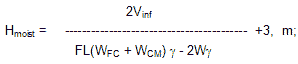
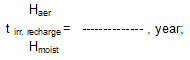
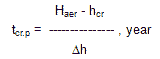
In the north part of the valley, under mentioned duties of water, moisture raised to field capacity in first year of development. Thus, there were considerable recharge of ground waters and their intensive rise. Studies of horizontal drainage operation were conducted by the Institute for Soil Science (A.M. Amindzjanov). They showed, that constructed drainage system slightly decreased ground waters level. About 30-40 t/ha/year of toxic salts were removed with drainage waters and soil salt content was improved. There was quite another picture in the central and south parts of the valley where ground waters were bedded at a depth of 20-60 m and more. Here, within the profile of aeration zone in upper 4 m horizon there is continuos change in moisture caused by irrigation water application, evaporation, transpiration and infiltration. Below 4 m horizon there is gradual increase of moistened zone with annual moisture increase at 2-4%. Average intensity of this zone moistening accounts for 4-5 m/year. Joining of its front to capillary fringe determines the beginning of recharge by infiltration waters. Value of irrigation water accumulation in aeration zone and ground waters recharge can be calculated by water storage and water balance of aeration zone. Infiltration within aeration zone (below 4 m) accounts for 15-35% of the value of irrigation norms. For new developed lands the following formulas are recommended:to calculate volume of aeration zone and ground waters recharge by infiltration

to calculate depth of moistening
to calculate the beginning of ground waters recharge by irrigation water
to calculate average ground water level rise

to calculate period when the ground water level reaches the critical point in order to forecast construction of drainage network
Over five years of drainage operation 74,6 mln m3/ha of saline drainage waters were removed with 793,3 th. t salts, i.e. 14,1 th. m3/ha of water and 150 t/ha of salts respectively. At such rates, having 800-900 t/ha of salt storage (upper 8 m) desalinization will require more than 25 years of irrigation.
|