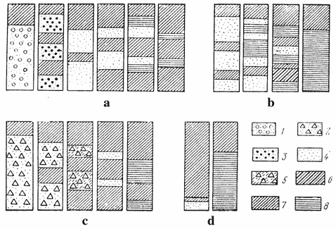
Lithological description of main region of irrigated farming developmentIn the regions of irrigated farming development lithology is very important for distin-guishing geomorphological rayons. Each geomorphological rayon or hydrogeological basin with respect to its genesis (alluvial, proluvial, limnic, fluoglacial, etc.) have own regularities in lithology determining conditions of irrigation drainage system operation. On fig. 3 typical lithological cross-sections for major rayons of irrigation are given.
a - alluvial plains; b - pre-mountain plains; c - delta and sea-side low elevations;
d - watersheds; 1 - pebbles; 2 – coarse peble with loam; 3 – gravel; 4 - sand; 5 - crushed stone; 6 - sandy loam; 7 - loam; 8 - clay.
Mountain plains well drained by rivers fine-grained deposits are underlain by thick-ness of highly permeable soils. Pre-mountain plains well drained and provided by ground wa-ter outflow are presented by fine-grained deposits underlain by coarse disintegrated material. For these rayons two genetic types of cross-section are typical: the first is connected with large rivers alluvium (pebble and gravel), the second with provisional streams (desinte-grated coarse and fine-grained material). Lithology of middle river terraces are characterized by fine-grained deposits underlain by sand and gravel. There are not impermeable interlayers close to land surface. Free outflow is provided to natural sinks (rivers, gulleys). On lower river terraces and secondary drained river cones flacky thickness of fine-grained deposits is underlain by sands of higher permeability. Low hydraulic gradients and soil water-physical properties slow down filtration rate. Alluvial-proluvial cones of withdrawal and alluvial-proluvial plains are characterized by sharp changes of soil along the profile. On alluvial plains sandy fractions prevail which in lower reaches are replaced by clay and loam. Thickness of cover deposits increases from young to old terraces (from 2-5 up to 25-40 m). Watersheds are presented by thick loess deposits underlain by fluvioglacial and an-cient alluvial sands. For close to sea lower elevations heavy clayey soils are typical interlaing with small-grained sand. Permanent sedimentats accumulation occures, because rayon is practically without outflow, intensive soil salinization and water logging of substantial area have place. |