Geomorphological-hydrogeological indicators
of the Aral Sea basin
Desert zone of the Central Asian republics is a zone of ancient irrigation. In many classifications the highest taxonomic units are: Turan plain, mountains Pamir, Tyanshang and Turkmen-Khorasan mountain country.
In turn, each taxonomic unit consists of different provinces with correspondent origin (genesis) of sediments, lithology, relief, etc.
According to climatic indicators with respect to geomorphological peculiarities two large ecological-landscape zones are distinguished: desert depression and pre-mountain plain. Geomorphological structures. Including relief formation and lithological features, present complexes of natural conditions, determine surface gradients and territory drainability, i.e. surface and underground flow (runoff) and tendency of ecological-meliorative processes un-der irrigation.
According to geomorphologic-lithological indicators within the Aral Sea basin 7 large landscape-geographic-geomorphological regions (oblasts) which, in turn, are divided into lot of rayons, sub-rayons and sites (fig. 1 and fig. 2).
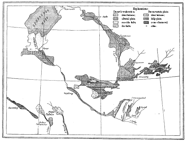
Fig. 1. Landscape zoning of Central Asia
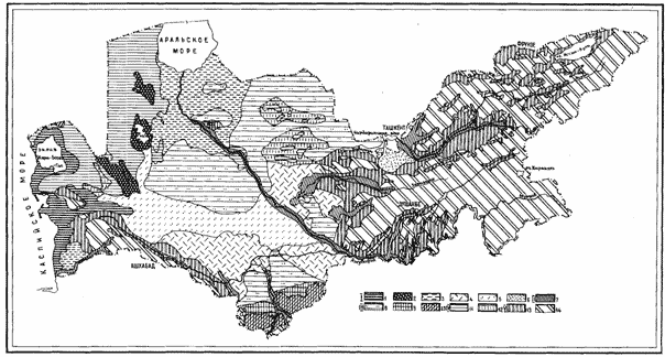
Fig. 2. Geomorphological provinces and genesis of aquifers deposits
(Hydrogeological map of Central Asia, Soyuzvodproekt, 1990)
I. Lower accumulation plains; aquifers deposits: 1 - maritime; 2 - lake; 3 - delta alluvial-maritime; 4 - sub-aerial-delta; 5 - ancient alluvial; 6 - alluvial-proluvial.
II. Accumulation terraces in the modern rivers valleys; deposits:
7 - modern alluvial. III. High denudation-accumulation plains: deposits: 8 - eolic-delluvial; 9 - alluvial-proluvial;
10 - eluvial-deluvial. IV. High denudation plateous; deposits: 11 - eluvial-deluvial; 12 - alluvial-proluvial. V. Mountain massives, pre-mountain-mountain and in-ter-mountain plains; deposits: 13 - alluvial alluvialproluvial; 14 - eluvium and exposures of bedrocks.
There are 4 rayons within desert depression and 3 rayons within pre-mountain plain.
In desert depression they are:
- river terraces (middle and lower), slightly drained in natural conditions;
- alluvial plains, bowls without ground water outflow;
- sea deltas-without outflow;
- dry deltas of small and medium rivers;
Within pre-mountain plains they are:
- river terraces of upper and middle reaches;
- corrugated pre-mountain plains drained in natural conditions;
- cones of withdrawal upper part of which is well drained but lower part has not ground water outflow.
Geographic-geomorphological structures of mountain corrugated plains, upper and middle river terraces and cones of withdrawal with good natural drainability could be distin-guished as oblasts which do not require complex measures on management of ecological-meliorative processes.
In these rayons main task is water management in order to minimize its losses and pre-vent degradation (flash and erosion) of soils.
In rayons with medium natural drainability and without ground water outflow com-plex ecological-meliorative processes develop under irrigation: water logging, secondary salinization, surface and ground water quality aggravation. In this connection for these eco-logical-meliorative processes management more complex water saving and conservation measures and irrigation and drainage technologies are required.
|