Tukmenistan
The climate of Turkmenistan is sharply continental, with the exception of the inshore zone of the Caspian Sea and the mountains. Average annual air temperature along the whole territory is positive and ranges on plain part of Turkmenistan from 12oC-17oC in the north to 15oC-18oC in the south-east. The coolest month is January with the average temperature from - 6oC in the northeast of Turkmenistan to + 4oC in the south-east and + 5oC in the end west. Average temperature of the hottest month - July, is 27-30oC. The absolute maximum reaches 48-50oC in Central and south-east Karakum, being a little diminished in the north of Turkmenistan, at the coast of the Caspian sea and in mountain areas. The biggest amount of sediments along the territory is observed in the mountains, and in forelands - average is up to 398 mm (Koyne-Kesir), the smallest - above Kara-Bogaz-Gol bay (95 mm) and northeast of Turkmenistan (105 mm).
Source: GRID-Arendal
Water resources
By the availability of the water resources Turkmenistan occupies one of the last place among the republics of the former Soviet Union. At present, the main source of water supply is the Amudarya river. The quality of the drinking water is also vital for the human health.
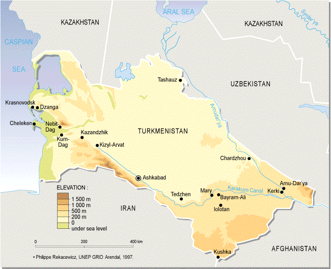
The water resources in Turkmenistan can be subdivided into surface and underground water. Among the surface water resources in Turkmenistan, the most important are the Amudarya, Murgab, Tedjen and Atrek rivers. The small rivers are insignificant and depend on groundwater.
The Amudarya plays a key role in the water supply of Turkmenistan. The largest man-made waterway, the Karakum River takes annually 10-12 km3 of water from the Amudarya and delivers it to the poor in water or waterless regions of Turkmenistan. The Amudarya is the main, vital water source covering nearly 90% of the water demand in the country. Other relatively large rivers in Turkmenistan (Murgab, Tedjen, and Atrek) have a total average annual flow of 2.7 km3, and a flow of 90% probability - 1.4 km3. Thus, the total water resources of the average annual river flow of big rivers, small rivers and springs are 27.1 km3/year, while a flow of the 90% probability is 22.8 km3/year.
The extensive network of irrigation canals is built on the plains, especially in the oases. The largest of these is the Karakum River, which is more than 1,100 km long. Its average annual water intake can reach 340-380 m3/s, which is 3-4 times more than the total flow of the Murgab, Tedjen, Atrek rivers and rivers on the northeastern slope of the Kopetdag
In comparison to other Central Asian states, Turkmenistan has the lowest operational resources of groundwater, 60% of which are formed from the runoff lost through infiltration. As of 01.01.1999, the approved groundwater resources for the entire country were 3.36 million m3 a year.
Apart from the aggravating situation with water supply in the recent years, the most serious problem is the protection of water resources from discharges pollution. The volume of wastewater and drainage water in Turkmenistan is 8.74 km3, of which 6.62 km3 is drainage water. Practically all discharged waters are diverted without any treatment into the deserts, rivers, and irrigation sources, thus deteriorating the quality of water and nature.
Of the total amount of drainage water more than 3,6 km3 are diverted into the water bodies and rivers, which makes their water quality worse. In the lower reaches of the Amudarya, water salinity in the low-level period increases to 2.5-3.0 g/l, and in some times contains 25-30% of drainage waters. The high level of lead and cadmium, the elements that are extremely harmful for the human health, was demonstrated recently in the river waters.
Great concern is caused by the essential deterioration of the water quality along the Karakum River because of the diversion of drainage waters and industrial wastewater into the River, especially from the nearby industrial centres such as Mary, Tedjen, etc.
For the last years, the Amudarya River invariably was on the top of the list of the most polluted water bodies of the Central Asian region. The salt content of drainage waters disposed into drainage networks and main drains on the left and right banks of the Amudarya River indicate the pollution level on the agricultural lands.
The main sources of polluted wastewater are of a localized character. They incorporate, first of all, industrial enterprises, public utilities, and some other localized sources (garbage grounds, animal farms, storehouses for chemicals and mineral fertilizers, waste storage, etc.).
Drainage flow consists of drainage water and of some non-production technological disposals of the irrigation water into main drains. One of the main causes of the large volume of drainage water, is an overly high rate of the irrigation water supply. At present, the amount of drainage water is 37 to 54% of the supplied water while the norm is 20-25%.
Land resources
In 1998, the total land area of the country was 49.12 million hectares of which agricultural lands were 34.508 million hectares.
The land areas of Turkmenistan are characterised by their major soil types. Sandy desert and grey-brown soils cover the largest area. Other soil types take from 3 to 8% of the total area of the country; the share of mountain soils is about 5%.
In total, 49.12 million hectares are irrigated and drained lands in Turkmenistan, while lands suitable for irrigated farming are estimated at 7,013,300 hectares. Irrigated and drained lands exist in all velayats, but their greatest potential is in the Balkan and Akhal velayats. According to their salinity level the soils are non-saline; slightly saline; medium saline; heavily saline; and very heavily saline soils and solonchaks.
According to their soil texture, reclaimable lands have coarse soils (sandy, loamy sandy); medium soils (loamy and sandy clay), and fine soils (heavy loam and clay). Also according to the depth of groundwater in irrigated and drained lands the categories of soils are 2 m or higher; between 2 to 3 m of depth; between 3 to 5 m of depth; and below 5 m.
The existing level of salinisation is a major feature of soil degradation. It varies by types and forms of its manifestation, and is determined by both natural and anthropogenic factors, among which drainability of the terrain deserves a special mention.
Salinization is a product of meadow soil formation which most often occurs in poorly drained terrain where groundwater lies at the depth of 2-3 m or higher (with a seasonal amplitude 0.8-1.0 m).
In the irrigated fields, dissolved salts are pushed by the irrigation water deeper into the soil, and in the field margins, spread to the vacant lands. The excessive salt content in natural non-irrigated areas is registered throughout the entire soil profile, while in the irrigated lands it occurs below the depth of 30-80 cm.
In the drainless conditions, high irrigation rate (15,000-17,000 m3/hectare) affects the soil formation already in the fifth to sixth year of irrigation. Application of high irrigation rates on the lands, which are not properly prepared, causes an intensive groundwater rise, which leads to overwetting of the soils and enhances the secondary salinisation of the newly irrigated soils.
Salinization accompanies irrigation at all stages of the farming as a result of the rise of saline groundwater, the main source of soil salinisation in the oases. The closer to the surface the saline groundwater is, the more intensive is salt accumulation in soils. The depth at which the groundwater lies is the key factor of soil degradation, and therefore the groundwater level has to be artificially controlled by construction of the drainage network.
The waterlogging of soils is one of the negative factors leading to land degradation. It is caused by groundwater, which rises close to the surface (from 0.3 to 1.0 m) in both irrigated and virgin lands. The groundwater can have variable salinity. The waterlogging usually develops in the zone near the irrigation canals, in the depressions between canals, and in the irrigation ditches to which the infiltration water from the canals and irrigated fields flows.
The erosion during irrigation also contributes to soil degradation in irrigated farming. In Turkmenistan, the erosion is most widespread on the inclined terrains of the northern and western parts of the Kopetdag piedmont plain. A territory is considered under the threat of erosion if its slope is more than 0.002. Here, runoff contributes to the displacement and removal of the fine soil particles.
In Turkmenistan, practically all irrigation systems are constructed in the earthen beds, which leads to great seepage losses from the irrigation canals and to the rise of the groundwater table. About 55 to 60% of the irrigated lands need priority improvement. Apart from leaching, these lands need construction of the new drainage systems and repair of the existing ones, complete reconstruction of the irrigation network, fundamental levelling and improvement of the water supply, and the application of different and optimal irrigation and drainage regimes.
The salinisation can be controlled by application of the new, progressive methods of irrigation, improvement of the existing agricultural practices, application of more efficient crop rotations, optimal rates of organic and mineral fertiliser application, etc. The land levelling is one of the radical means to prevent salinisation.
Currently, about 50% of the irrigated lands in the country are considered to be in unsatisfactory state because of the groundwater occurring too close to the surface.
|