Republic of Tajikistan
The climate of Tajikistan is continental, characterized by considerable seasonal and daily fluctuations of temperature, humidity and other meteorological elements. The annual average sunshine varies from 2,000 to 3,160 hours.
The precipitation distribution depends mainly on the location and orientation of mountain ranges and, consequently, on the air mass circulation. Thus, in the hot deserts of southern Tajikistan and cold high-mountain deserts of the Eastern Pamirs, mean annual precipitation varies from 70 to 160 mm, while the maximum is observed in central Tajikistan, where it can exceed 2,000 mm. The most humid areas are western and southwestern exposed to the wind slopes.
The unique local types of the climate are formed due to the complicated relief and the great amplitude of altitudes. Mean annual air temperature varies over the area of Tajikistan within a wide range: from + 17°C in the south of the country to - 7° C in the east. The highest temperature is observed in July, and the lowest temperature is in January. Mean annual air temperature reaches +14 to +17°C in the valleys of southwestern Tajikistan, +14 +15°C in the valleys of northern Tajikistan, and +6 +11°C in foothill areas. The high-mountain areas of the Western Pamirs are characterized by a more severe climate. Here, mean annual air temperature is close to zero, rising up to +6+8°C in the lower reaches. Particularly severe climate is observed in the Eastern Pamirs, where mean annual air temperature is mainly negative, -1-6°C. The absolute minimum is observed in Bulunkul Lake (-63°C).
Source: GRID-Arendal
Water resources
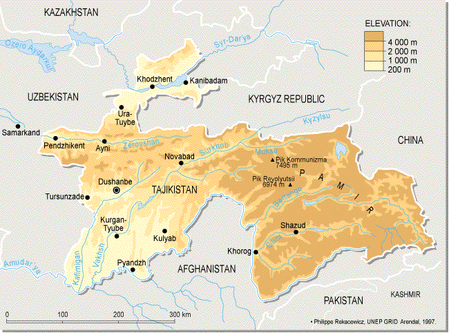
Tajikistan is rich in water resources. It is necessary to note that mountains of Central Asia occupying 20% of the total area of the Aral Sea basin (350 thousand sq. km) gives 90% of surface runoff. On average, the water flow formed in this zone is 115 cub.km mainly within Amudarya and Syrdarya river basins. On average, 51.2 cub.km of water is formed on the territory of Tajikistan which comprise 44% of annual water flow of the Aral Sea basin rivers: in the basin of Amudarya River - 50.5 cub.km and Syrdarya River - 0.7 cub. km. The main water flow comes from Pyanj, Vakhsh, Kafirnigan, Bartang and Zeravshan river basins.
Tajikistan’s water resources mainly arise owing to glacier melting and precipitation. Total freshwater reserves in Tajikistan’s glaciers and snowfields are estimated at 550 cub. km. Many of them are located in the basins of Obihingou, Gunt, and Muksu rivers as well as in other high-mountain areas. Glaciers and snowfields occupy about 6% of country’s territory. Over 1,300 lakes contain 44 cub.km of water, including 20 cub.km of freshwater and 24 cub.km of saltwater. Their total area is 705 sq. km.
Peculiarity of mountain territory and plenty of water supply sources promoted the development of rich river network, numbering 947 rivers with length more than 10 km and with total length 28,500 km, which have glacier-snow and rain feeding. Surface runoff varies from place to place and in some areas exceeds 45 l/sec/sq.km. The maximum water discharge is observed in June-August when snow and glacier melting is most intensive.
There are 9 water reservoirs containing from 0.028 to 10.5 cub.km of water. The largest reservoirs are Kairakkum on the north of Tajikistan, and Nurek in the central part of Tajikistan. They are mainly used for electric power generation, irrigation, fish breeding, water supply, and mudflow protection.
Groundwater used in national economy is mainly located in quaternary alluvium of the large river valleys (Syrdarya, Kafirnigan, Vakhsh, Kyzylsu, Yakhsu) and intermountain depressions.
According to resent surveys, potential reserves of groundwater make 17 cub. km/year. Exploited reserves are estimated at 2-3 cub. km/year. On average, households, drinking water supply, industrial processes, and irrigation of lands consume 6,500 thousand cub. m of water per day. Fresh groundwaters are spread within earth horizons 1 to 100 meters. There is a wide range of medicinal, thermal and mineral water sources and springs in Tajikistan totaling 200 sources. Sulfate, ferrous, iodine, bromine, radon and siliceous water compositions can be found here. The springs in Taboshar, Adrasman, Yavroz, Anzob, Obigarm, Khoja-Obigarm, Karatag, Shambari, Babatag are most popular. Great diversity of springs can be found in the Pamirs: Garm-Chashma, Bahmir, Elis, etc. In the south there are brines with high salinity 400 g/l.
The main water consumer in Tajikistan is agriculture, particularly irrigation. It consumes up to 93% of total freshwater intake. Actually, about 95% of all vegetal agricultural production comes from irrigation areas. Domestic and industrial sectors consume accordingly 3% and 4%. Thus, industrial sector uses surface and groundwater equally. Average annual water consumption makes 12.5 cub. km, and wastewater volume is about 4.5 cub.km. The largest water consumption 15 cub.km was in 1977-1984. At present, the share of water use by Tajikistan in accordance with multilateral agreements makes 12-14 cub.km. For the last 30 years, water consumption in Tajikistan has increased by 40%.
Actually, 74% of all consumed water is used for regular irrigation, 3% for domestic needs, 4% for industrial processes, and 4% for agricultural water supply. Water losses during transportation reach 17%, that is a direct consequence of low efficiency (0.55-0.65) of irrigating channels and water transportation structures. The direct irrigating method consumes 14-16 thousand cub.m/ha of water, whereas alternative methods could reduce water use by 15-25%, however they are not applied yet because of high costs. Total area of irrigated lands in Tajikistan exceeds 720 thousand hectares. Cotton is the main irrigated agricultural crop.
Annual volume of groundwater consumption is 1 cub.km that is withdrawn from 5 thousand groundwater wells and batches. Industry and municipal services mainly use groundwater. Intensive pollution of groundwater horizons because of infiltration of irrigational wastewater along the left bank of Syrdarya River promotes the lack of drinking water in northern regions. Similar problem is observed in southwest Tajikistan.
Significant amount of suspended solids in Tajikistan’s rivers results in the loss of water reservoir’s functionality, and as consequence reduces the potential of electric power generation.
Water consumption for irrigation caused significant changes of the hydrological conditions in some river basins. For example before irrigation, maximum water discharge in Yavansu River did not exceed 2-3 cub. m/sec (April), whereas after irrigation, maximum discharge has increased to 20 cub. m/sec (August). Besides, the processes of coastal erosion and gully formation have been essentially enlarged.
The climatic factor directly impacts the state of hydrological resources. Drought years result in frequent water shortage. The rapid increase of summer temperatures promotes the formation of flooding waters. Heavy rainfall in spring-summer season forms widespread mudflows and landslides, and thereby causes significant damage to the agriculture, settlements and communications. It is likely that water resources in many regions of Tajikistan will decrease due to the climate change.
Land resources
Land resources are important for sustainable development of the nation, as well as for economic, ecological, and social well being. In Tajikistan, they represent the basis for irrigated and rain-fed farming, gardening, and pasturing. Low-productive stony and desert soils, rocks, and glaciers comprise the greater part of the country’s area. Primordially low productivity of soils leads to their intensive use and, consequently, further soil degradation.
The total area of the land resources of Tajikistan is 14.3 million hectares. Nearly 4.6 million ha are currently agricultural lands, including 3.6 million ha of pastures and 720-840 thousand ha of arable lands, and over 100 thousand ha of perennial plantations. Rocks and debris occupy 17.5% of the total area, glaciers and watercourses - 9%, forested areas - 3%, urbanized areas (settlements, transport, industrial lands) - about 2%.
In 1997-2001, over 20 thousand ha of irrigated arable lands left fallow because of unsustainable land resources management and soil salinization, swamping, and erosion. The lack of water and spring floods also played a particular role.
|