Republic of Kazakhstan
Diversity of geological, geomorphological, climatic, soil and vegetation conditions on the territory of the Republic of Kazakhstan implies variety of landscapes. Average temperature of January, the coldest month, ranges form —50°C in the southernmost areas to —20°C in the north. On the plain part of Kazakhstan average July temperature ranges from +18°C in the north to +29°C in the south.
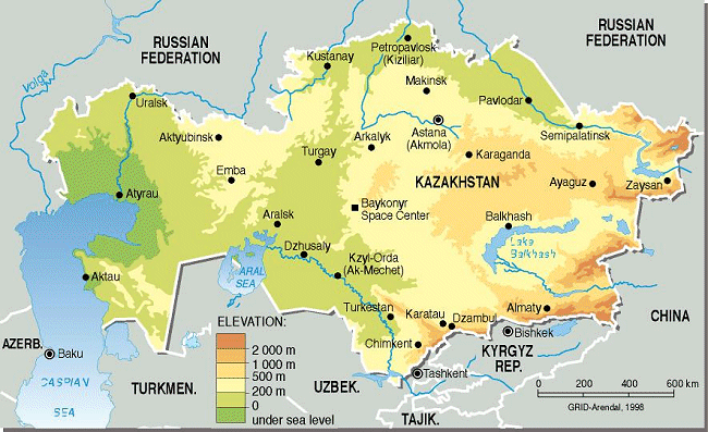
Source: GRID-Arendal
Water resources
The total water river resources in the year with an average water content make 100.5 km3, and those that can be used — 46 km3. The rest of the water volume is spent for environmental, fishing, sanitary (29 cubic meters), transport and power (9.0 cubic km) needs, filtration and other types of losses (12%).
The specific water supply makes 37 thous. m3 per 1 km2 and 6.0 thous. m3 per person per year. The water resource deficit, with an average water content for many years, reaches 60%, and by separate regions (the Central Kazakhstan) only 50-10%, and the deficit is characteristic mainly for the irrigated land cultivation. The water resource deficit causes are the natural conditions (90% of the river runoff takes place during the spring period), formation of about half of the flow (56.5 km3) on the territory of neighboring countries, extensive use, excessive unrecoverable water consumption for irrigation, and water losses. In addition, the surface water resources in the republic are distributed extremely unevenly are subjected to considerable time fluctuations.
The Republic of Kazakhstan is characterized by a wide variety of water objects possessing more than 39 thous. of rivers and ravines. They belong to the internal closed basins of the Caspian (Ural, Emba), and Aral (Syr-Daria) seas and the lakes Balkhash (Ili, Lepsy, Aksu, Karasu and others), Alakol (Emel) and Teniz (Nura), and only the river Irtysh refers to the basin of the Northern Ocean.
The most density of the river network (0.4—1.8 km/km2 ) is characteristic for alpine districts of the Altay, Dzhungar, and Zailiysk Alatau, and the least one for the districts of the Aral and Caspian (less than 0,03 km/k2) sand deserts; by the nature of sources the rivers refer in principal to three types: of primarily snow, glacier, and mixed sources. In correspondence with the majority of river sources of the RK, flood-time at the rivers with glacier sources takes place mostly during the summer period. Glaciers and eternal snow play a considerable role as sources of rivers in alpine zones.
The following 7 rivers have the length of more than 1.000 km: Irtysh, Ural, Syr-Darya, Ili, Ishim, Chu, and others. 155 rivers are more than 100 km long, and more than 6 thous. of rivers are more than 10 km long. There are only 6 rivers in Kazakhstan with water consumption of 10 to 1.000 m3 / sec.
Water quality in the Prearalie
Syrdarya
The quality of water of these rivers, excepting Syrdarya, is characterised as clean (2-nd class, IWP – 0.62-0.76).
Level of pollution of the Syrdarya River within the South-Kazakhstan Oblast characterise on two river stations (IWP – 3.4; 4-th class - polluted). On the data of observations the contents of such polluting substances, as sulphates, copper, phenols were on the average within the limits of 2-6 MAC. The maximum level of pollution was observed in the spring period, when the contents of polluting substances reached the following indicators: copper and nitrites - 16 MAC, sulphates - 7 MAC, phenols - 6 MAC, oil products - 4 MAC.
Water of the Shardary reservoir is polluted basically sulphates, nitrites, phenols and copper, IWP makes – 2.9 (4-th class - polluted).
Keles
Water of the main tributaries of the Syrdarya River is also considerably polluted. The Keles River is characterised by IWP of 4.3 (5-th class – very polluted). The basic polluting substances are sulphates, copper and phenols, which contents was within the limits of 2-11 MAC.
Arys
The Arys River is moderately polluted (sulphates, copper, phenols and nitrites).
Badam
The level of pollution of the Badam River is characterised by MAC of 3.2 (4-th class - polluted), average concentration of sulphates, copper, phenols, nitrites and oil products exceed MAC 2-5 times.
Transfer and Fall of Salt from the Dried Part of the Aral Sea Bed
On the Kazakhstan part of sea bed currently there are several sources of aerosol transfer. The total average annual transfer of aerosol for many years under 50% of probability from all sources of the Kazakhstan part of sea bed is estimated at 1.13 million t under reduction of water level by 15 m (Semenov O., 1995). It shall be mentioned, that there are considerable climatic fluctuations in the wind transfer of the Aral Sea aerosol. There are periods of higher and lower activity of the processes. In observations, being considered, there is an obvious general trend of reduction of transfer volumes, which is associated with reduced wind speeds, caused by global climate changes. By assessment of climatologists, change of circulation epochs takes place currently and it is expected that wind activity will begin to increase in future, as well as intensity of deflation process on the Aral Sea bed.
Comparison of values of average dry falls of aerosols for many years in the Kazakhstan part of the Aral Sea region from storm plumes and lift of particles from surface through convection, obtained in compliance with the model of the Kazakh Research Hydrometeorological Institute, with the map of dry falls in the southern part of the Aral Sea region, prepared by the Uzbek scientists Razakov and Kosnazarov (Razakov R., Kosnazarov K., 1987), shows, that in the eastern part of the Aral Sea region along the coastline aerosols fall to the surface approximately 1.5 times more – up to 145 per square km a year. In the northern part of the Aral Sea region dry falls are close to their values in Amu-Daria delta. The map shows, that the most part of the sand and salt aerosol, transferred by wind, falls from air streams at the distance of several dozens of kilometers from the source. At the pictures, taken from space, it can be seen, that transfer plumes of strong storms have length up to 200-400 km, i.e. the remaining part of particles falls at a distance of several hundreds of kilometers. And only insignificant amount of the smallest particles during very strong storms can be taken away to the large distances. Taking into consideration the forecasted volumes of transfer of the Aral Sea aerosol for the next decade, it can be expected, that only due to growth of geometrical sizes of the source of transfer, average transfer of the aerosol amount for many years will increase to 1.29 million t a year. Most probably, figures will be larger, since already at the beginning of 90-ies growth was accounted in the trends of sand transfer, and most obviously, stage of reduced intensity of deflation processes, observed in 80-ies, will be followed by the period of increased wind activity.
Main river basins of Kazakhstan
From: Water Resources of Kazakhstan in the New Millenium, UNDP, Almaty, 2004
The territory of Kazakhstan can be conditionally divided into 8 hydro-economic basins: AralSyrdarya basin, Balkhash-Alakol basin, Irtysh basin, Ural-Caspian basin, Ishim basin, Nura-Sarysu basin, Shy-Talas basin and Tobol-Turgai basin.
Aral-Syrdarya Basin
The Aral-Syrdarya basin occupies an area of about 345,000 km2 and includes two administrative regions: South Kazakhstan and Kyzylorda. The population of the basin is about 2.6 million people (17% of the total population of the Republic), including an urban population of 1.2 million people (46% of the total population of the basin) and a rural population of 1.4 million people (54%).
The main river of the basin is Syrdarya, which begins outside Kazakhstan in the Fergana Valley at the junction of the rivers Naryn and Karadarya. The total length from the junction is 2,212 km, and from the source of Naryn is 3,019 km, The length of the river within the territory of Kazakhstan from the Shardary Water Reservoir to the Aral Sea is 1,627 km, including 346 km in the territory of South Kazakhstan and 1,281 km in the territory of Kyzylorda Oblast.
The largest tributaries of Syrdarya within Kazakhstan are Keles, Arys, Badam, Boroldai, Bugun and smaller rivers, flowing from the southwestern slopes of the Karatau Ridge.
The area of the basin of the Syrdarya River from the source to the railway station Tyumen-Aryk, where the watershed line can be observed, is 21,900 km2. In the source zone (the mountainous part of the basin) the principal source is seasonal snowmelt, with a less significant volume from glaciers and perennial snow, as well as rain.
Average water resources of the basin of the Syrdarya River equal 37.9 kin'. Some 70% of the water flow forms in the upper part of the basin prior to its exit from the Fergana Valley. The flow of the right bank tributaries above the Shardary Water Reservoir comprises 21-23% of the total water resources coming into Kazakhstan. The share of the flow of the Arys River, as well as other rivers flowing from the Karatau Ridge in Kazakhstan, is 7-9%.
Balkash-Alakol Basin
The Balkash-Alakol basin occupies a vast area of the southeast of Kazakhstan and a part of the adjacent territory of China. Its area is 413,000 km2, including 353,000 km2 of the territory of Kazakhstan. The Kazakhstani part of the Balkash-Alakol basin includes the territory of Almaty Oblast; the Moyinkum, Kordai ans Shu Districts of Zhambyl Oblast; the Aktogai. Shet and Karkaraly Districts of Karaganda oblast; the Urdzhar and Ayagoz Districts of East Kazakhstan Oblast; the Chinese territory includes northwestern part of the Jingxian-Uighur Autonomous Region. The major megalopolis of Kazakhstan, Almaty, is also situated in this basin.
The population of the Kazakhstan] part of the basin is about 3.3 million people. The majority-1.6 million people - resides in Almaty Oblast. The rural population comprises 1.5 million people.
The water reserve of this basin is significant, amounting to 149.4 km". However, the main volume of m concentrated in the mountains, mainly in the Balkhash Lake, and cannot be used for irrigation of the lands of Almaty Oblast. The share of water in the rivers is 14%, and in water reservoirs just
Irtysh Basin
The Irtysh River basin includes the lrtysh River and its tributaries. The Irtysh River is one of largest rivers in Kazakhstan. Its length, including the Black lrtysh is 4,200 kilometers.
The average flow rate of the Irtysh River at its entry into the territory of Kazakhstan is about 300 mi/sec (9 kmi/year and at the border with Russia, the village of Cherlak, is 840 m3/sec (27 km3/year).
There are three major water reservoirs on the Irtysh River within the territory of Kazakhstan: Bukhtarma, Ust-Kamenogorsk and Shulba water reservoirs, which have a regulating effect on the river's flow.
This basin is the most secure in respect to its water resources. The water reserve comprises 43.8 km3. The principal water reserves are formed by the river flow - 26.04 km3 (59%). The capacity of water is the largest in Kazakhstan and comprises 7.7 km3 (18% of the basin water reserve). About the same volume of water is contained in the lakes- 16%.
Ural-Caspian Basin
The Ural-Caspian river basin within the territory of Kazakhstan occupies an area of 415,000 km2 and includes the catchment area of the Ural River (236,000 km2), the Volga-Ural inter-fluvial area (107,000 3nd the Ural-Emba inter-fluvial area (72,000 km2).
In general, the Ural River basin includes a part of the territory of the Russian Federation, and in the republic of Kazakhstan it includes West Kazakhstan Oblast, Aryrau Oblast and a part of Aktobe Oblast. The population of the Ural-Caspian basin within the Republic of Kazakhstan is about 2.2 million people.
The water reserve comprises 28.0 km3, including the Ural River basin - 11.4 km3, the Volga River basin - 13.4 km3 and by the basins of the rivers Uil, Sagiz and Emba-15.2 km3. The river waters comprise 94% of the total reserve, water reservoirs and ground water, 3% each.
A peculiar feature of this basin is that almost half of the surface drainage is located on the River Kigach, which is a branch of the Volga River estuary and is situated in the mouth, thus preventing use of : discharge of this river. Therefore, the principal water artery of the basin is the Ural River, which discharges 8.25 km3 out of 11.6 km3 and rises on the territory of Russia.
Ishim Basin
The ]shim River basin within the territory of the Republic of Kazakhstan occupies an area of 45.000 km2 (215,000 km2). Its population is 1.9 million people, including 1.09 million rural dwellers (57%).
This basin is the least secure in respect to water resources. The water reserve comprises 5.34 km3. The majority of water reserves are contained in lakes-55%, with river discharge comprising 34%. Only 7% of the water accumulates in water reservoirs. Ground water reserves here are the lowest in Kazakhstan at just 0.19 km3 (30 times less than the reserves of the Balkhash-Alakol basin) and comprise only 4'% in the water balance of the basin.
The principal water artery of the basin is the Ishim River, with a number of large tributaries, flowing down in the north from the Kokshetau upland, and from the flanks of Ulytau Mountains. The Ishim River begins from springs in Niaz Mountains in Karaganda Oblast (the northern margins of the Kazakh rolling hills). Its length is 2,450 km, including 1,717 km in the territory of Kazakhstan within Akmola and North Kazakhstan oblasts. The most significant tributaries in terms of water reserves and length are the rivers Koluton, Zhabai, Tersakkan, Akan-Burluk and Iman-Burluk.
A peculiar feature of the rivers of the basin is their uneven flow distribution by seasons and years. Water discharge in different years may differ by a hundred times, which complicates the economic use of the resources of these rivers.
Nura-Sarysu Basin
The territory of the Nura-Sarysu basin includes the basins of the rivers Nura and Sarysu, and the lakes Tengiz and Karasor. The population of the territory of the Nura-Sarysu basin is about 1 million people.
The water reserve is smaller than that of the Ishim basin and comprises 4.59 km3. In order to increase water resources of this basin the Irtysh-Karaganda Canal (currently the Satpaev Canal) was built; its share in the projected filling may comprise up to 18% of the total balance. Ground water comprises 25%, other water resources include surface sources: lakes - 20%; water reservoirs - 4% and riverbeds - 33%. The largest river of the basin, the Nura, begins in the western flanks of Kyzyltas Mountains and flows into Tengiz. The length of the river is 978 km; the catchment area is 58,100 km'. The main tributaries of the Nura River are the Sherubainura, Ulkenkundyzdy and Akbastau.
The Sarysu River begins from two branches of Zhaksysarysu and 761 km from their junction the Sarysu flows into the Telekol Lake, Kyzylorda Oblast, near the village of Atasu. The total catchment area of the Sarysu River is 81,600 km2. The main tributaries are Karakengir and Kensaz.
The territory of the river basin is in regions with evidently insufficient humidity. The specific feature of the rivers of this basin is that the main annual water discharge (90% or more) is during the short spring flood. During low water in summer, autumn and winter, the discharge of the rivers significantly decreases, and in most rivers no discharge is observed.
There are about 2,000 lakes and 400 artificial reservoirs in the Nura-Sarysu river basin. The majority of lakes are in the basins of Nura and Karagalinka.
Shu-Talas Basin
The territory of the basin is formed by the rivers Shu, Talas and Asa. Its total area is 64,300 km2, including part of the territory of the Kyrgyz Republic. The population of the Kazakhstani part of the basin (Zhambyl Oblast) is 980,000.
The water reserve comprises 6.11 km3, which is 3.6 times less than in the Aral-Syrdarya basin. The ground water reserve comprises 1.65 km3, which is larger than in the Aral-Syrdarya basin, and the share of these reserves in the total balance is 27%. The other water resources are concentrated in surface sources: lakes - 6%, water reservoirs - 8% and rivers - 59%.
The majority of the territory of the basin (73%) is located in the zone of deserts and semi-deserts; spurs of the Tien Shan mountainous systems occupy 14% of its territory. From an agricultural point of view, most interesting is the piedmont steppe, which occupies 13% of Zhambyl Oblast.
In addition to the major rivers, the Shu-Talas Oblast has 204 small rivers (in the Shu River basin - 140 rivers, in the Talas River basin - 20 rivers and in the Asa River basin - 64 rivers), as well as 35 lakes and 3 major water reservoirs.
In the Kyrgyz Republic on the Shu River is the Orto-Tokoi Water Reservoir with a projected capacity of 0.42 km3 and on the Talas River the Kirovsk Water Reservoir has a capacity of 0.55 km3. Thus, the flow of the main rivers of the basins of the rivers Shu, Talas and Asa is fully regulated. The main purpose of the water reservoirs of the basin is irrigation.
The flow of the rivers Shu, Talas and Kukureu-su (the main tributary of the Asa River) is formed completely on the territory of the Kyrgyz Republic.
Tobol-Turgai Basin
The total area of the river basin, including the basins of the rivers Tobol, To rgai and Irgiz, is 214,000 km2. The territory of the basin extends in the meridian direction for 600 km, the extension from east to west being 300 km. The population of the basin is 1.05 million.
This is Kazakhstan's poorest basin in respect of water resources. The water reserve comprises 2.9 km3. Ground water comprises 15% and the remaining water is concentrated in surface sources: lakes - 33%, water reservoirs - 17% and rivers - 35%.
The surface flow of the rivers of the basin is formed exclusively during snowmelt. The annual flow of the rivers of the Tobol-Torgai basin can fluctuate significantly and is characterized by alternating highwater and low-water years. The duration of high-water periods varies from 8 to 10 years, and the duration of low-water years varies from 6 to 20 years. During the high-water years the flow of the rivers exceeds the average multi-annual values by 3-5 times, and during low-water years it lowers to 0.6-0.15 of the average multi-annual values.
The Tobol River begins in the Ural Mountains. It is a typical steppe river, with little water within the territory of Kazakhstan. Over 90% of the flow forms in spring. The left-bank tributaries of the Tobol River: Sytasty, Ayat, Ui also begin on the slopes of the Ural Mountains. The only right-bank river is the Ubagan River.
The natural regime of the Tobol River has been altered. Eight water reservoirs, including Upper Tobol and Karatomar reservoirs provide multi-year regulation of the flow.
Within the basin there are over 5,000 lakes, 80% of which have an area of less than 1 km2 and the majority of lakes dry up in summer. The major lakes are Kushmurun, Sarykopa, Aksuat and Sarymoyin.
Land resources
As of January 1, 2000 from 272.5 million ha of the area of the land fund agricultural lands occupied 222.5 million ha, of which 185.2 million ha are under pastures, 21.9 million ha – arable lands, 10.3 million ha – fallow lands; 5.0 million – haymaking. There are 13 ha of agricultural lands, including 2 ha of arable lands per resident.
Area of irrigated lands is 2.3 million ha, of which 1.4 million are under arable lands. Agricultural producers manage 106.7 million ha or 39.6% of the total land fund of the republic.
In the last two decades the problem of land degradation in arid regions becomes more and more urgent due to excessive use of arid lands, non-regulated grazing on pastures, deforestation and use of inadequate methods of farming. One and a half million hectares of 27 million hectares of arable lands in the Republic are damaged by wind erosion. As for water erosion, mostly damaged are the arable lands of South-Kazakhstan (317.7 thousand hectares), Akmola (319.9 thousand hectares), East-Kazakhstan (234.4 thousand hectares) and West-Kazakhstan (181.8 thousand hectares) oblasts.
In the result of violation of environmental balance and decrease of soil fertility degraded and low-production lands have to be withdrawn from arable lands.
|