
Section 2. Water-related situation in the Aral Sea basin
2.1. Water Management Situation in the Amu Darya and Syr Darya River Basins
Water Resources
In 2023, the total annual runoff in the Amu Darya and Syr Darya river basins amounted to 106.06 km3, which is 90% of the average long-term runoff.
Amu Darya River Basin
The annual runoff in the Amu Darya basin (Amu Darya and Zerafshan rivers) was 70.78 km3, of which 56.5 km3 is the runoff of the Amu Darya River at the nominal “Kerki" section (upstream of the water intake for the Garagumdarya canal). The flow of the Amu Darya River was 92% of the norm in the first quarter, 93% during the growing season, and 76% in October-December.
The total water storage in the Nurek and Tuyamuyun reservoirs was 12.82 km3 by January 1, 2023.
Syr Darya River Basin
In the Syr Darya basin, the annual runoff, including the Naryn, Karadarya, Chirchik rivers, as well as small rivers, is equal to 35.28 km3, of which 20.76 km3 is the total inflow to the 3 reservoirs - Toktogul, Andijan and Charvak.
By January 1, 2023, the total water storage in the basin’s reservoirs was 20.13 km3, including 12.88 km3 in large reservoirs (Toktogul, Andijan, Charvak) located in the flow formation zone.
Operation of Reservoir Hydrosystems
The annual inflow to the Nurek reservoir was 21.01 km3, including 16.8 km3 (80%) during the growing season. The annual outflow from the reservoir was 21.15 km3, with 13.28 km3 released during the growing season.
Due to insufficient inflow from the Panj River, the annual flow into the Tayamuyun Hydrosystem was only 20.08 km3, which was 4.33 km3 less than forecast. During the growing season, the inflow was 14.09 km3. The annual outflow from the reservoir was 19.54 km3, or 85% of the schedule set by the BWO Amu Darya, including 13.31 km3 during the growing season, which is 75%.
The annual inflow to the Toktogul reservoir, located on the Naryn River, was 12.24 km3, including 9.18 km3 during the growing season, or 75% of the annual inflow. The annual outflow from the reservoir amounted to 12.86 km3, of which 5.35 km3 (42%) was released during the growing season. The Toktogul Reservoir was drawn down by 0.62 km3, and its volume at the end of the year was 10.42 km3.
Water Allocation and Water Shortage
Water resources are allocated by the ICWC between the riparian states of the Amu Darya and the Syr Darya (allocation of water withdrawal quotas) on a hydrological year basis, i.e. for a period from October to September. However, the analysis below presents water allocation data for a calendar year (January-December).
Amu Darya Basin
In 2023, the Amu Darya river basin had a water withdrawal limit of 55.17 km3, of which 47.58 km3 was actually withdrawn. During the growing season, 33.19 km3 was withdrawn. Overall, 86% of the annual limit was utilized, including 84% during the growing season. The distribution of water withdrawals among the countries was as follows:
• Tajikistan: limit - 9.82 km3; actual withdrawal - 9.42 km3
• Turkmenistan: limit - 21.85 km3; actual withdrawal - 19.92 km3
• Uzbekistan: limit - 23.5 km3; actual withdrawal - 18.24 km3
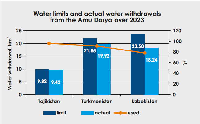
During the growing season, water shortages in the river reach between the Nurek hydropower plant and the Tuyamuyun reservoir (Darganata site) amounted to 3% for Tajikistan and 13% for Uzbekistan, while Turkmenistan experienced no shortages in this section. However, in the reach between the Darganata and the Samanbay site, Turkmenistan and Uzbekistan faced undersupplies of 30% and 38%, respectively, during the same period. These increasing water shortages along the river during the growing season can be attributed to uneven distribution across the territory.
Syr Darya Basin
The total water withdrawal in the Syr Darya Basin (up to the entry point of the Shardara reservoir) reached 13.65 km3, including 9.81 km3 during the growing season, which represents 82% of the canal water withdrawal limit. Additionally, 500 million m3 was discharged from the Syr Darya into the Arnasay Lake system.
Overall, 85% of the water allocation plan set by the BWO Syr Darya was implemented. Water shortages in the reach between the Toktogul reservoir and the Shardara reservoir amounted to 25% for Tajikistan, 30% for Kyrgyzstan, 23% for Kazakhstan, and 15% for Uzbekistan.
Inflow to the Aral Sea Region
According to the Committee for Water Resources of the Kazakh Ministry of Water Resources and Irrigation, the inflow into the Northern Aral Sea from the Syr Darya amounted to 2.04 km3 in 2023. No water was discharged from the Northern Aral Sea into the Large Aral Sea (Eastern Basin).
Based on research by SIC, the South Aral region is expected to receive 8 km3 of water from the Amu Darya River in wet years and 3.5 km3 in dry years. However, in 2023, only 2.71 km3 of water was delivered to the South Aral region.
Meeting Water Demandsе
The table below illustrates how water demands were met for the Central Asian states during the growing season.
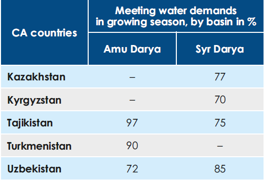
Source: SIC ICWC, based on the data from BWO Amu Darya and BWO Syr Darya
2.2 Large Aral Sea and the Amu Darya Delta
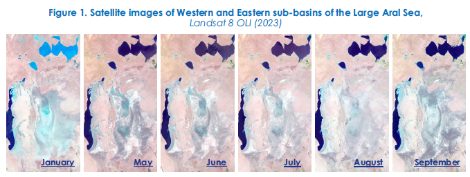
This section was prepared using data from the BWO Amu Darya, the Aral Sea Region Delta Authority, and the Uzbek Hydrometeorological Service (UzHydromet). The data was gathered also through remote sensing (RS) monitoring of the Eastern and Western sub-basins of the Large Aral Sea (LAS) and the lake systems in the Amu Darya River delta using Landsat 8 OLI images. Since 2022, refined threshold values have been used with NDVI for satellite imagery analysis to identify three surface categories: 1) open water surface, 2) wetland, and 3) dryland. Previously, the total water surface area was determined as the sum of open water surface and wetland areas. However, the challenge of distinguishing wetlands from dry, degraded land remained unsolved. The information for 2021 and 2022 has been updated using this improved methodology. Therefore, some discrepancies may be found when comparing this data with information from previous years.
2.2.1. Water Supply to the Amu Darya Delta and the Large Aral Sea
Water Supply to the Amu Darya Delta
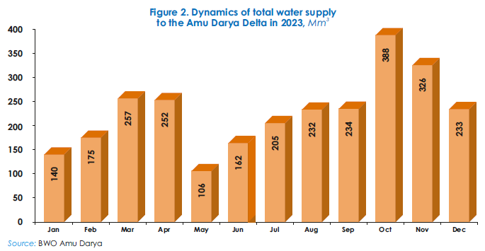
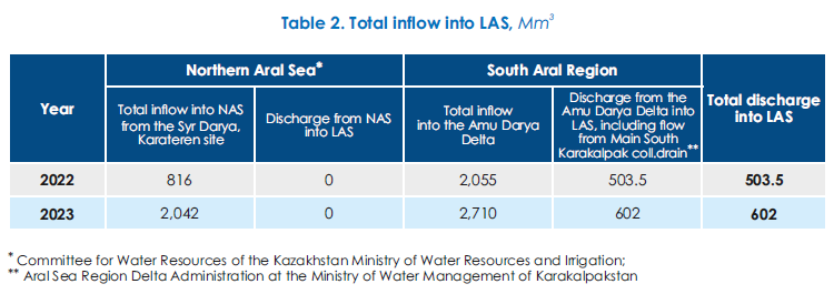
According to BWO Amu Darya, in 2023, 2,710 Mm3 of water (including river flow and water discharged from canals and collecting drains) reached the Amu Darya delta. This is 655 Mm3 more than in 2022.
Flow from the Main South-Karakalpak collecting drain towards the exposed bed of the Large Aral Sea
Bypassing the Amu Darya delta, 602 Mm3 of collector-drainage water flowed towards the exposed bed of the Large Aral Sea from the Main South-Karakalpak (Right-bank) collecting drain (Table 1). This is 98.5 Mm3 more than in 2022 (503.5 Mm3).

Total inflow into the Large Aral Sea
In 2023, the total inflow into the Large Aral Sea (LAS) increased from 503.5 Mm3 (2022) to 602.0 Mm3. The LAS got water from the Main South Karakalpak collecting drain (SKCD) only. No water was discharged from the Amu Darya River Delta and the Northern Aral Sea (NAS) (Table 2).
2.2.2. Open Water Surface and Wetlands in Eastern and Western Sub-basins of the Large Aral Sea
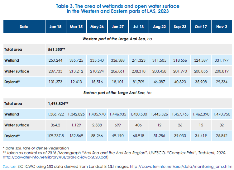
Based on monitoring and GIS data from January to November 2023, (1) in Western sub-basin of LAS: water surface area slightly decreased from 209.7 to 200.8 thousand ha, while wetland area significantly increased from 250.2 to 331.2 thousand ha, and dryland area decreased threefold from 101.3 to 29.3 thousand ha; (2) in Eastern sub-basin of LAS: water surface area decreased dramatically from 0.364 from to 0.032 thousand ha, fluctuating between a maximum of 2.59 thousand ha in May and a minimum of 0.012 thousand ha in August. Wetland area increased slightly from to 1386.7 to 1470.9 thousand ha (Table 3).
2.2.3. Lake Systems in the Amu Darya Delta
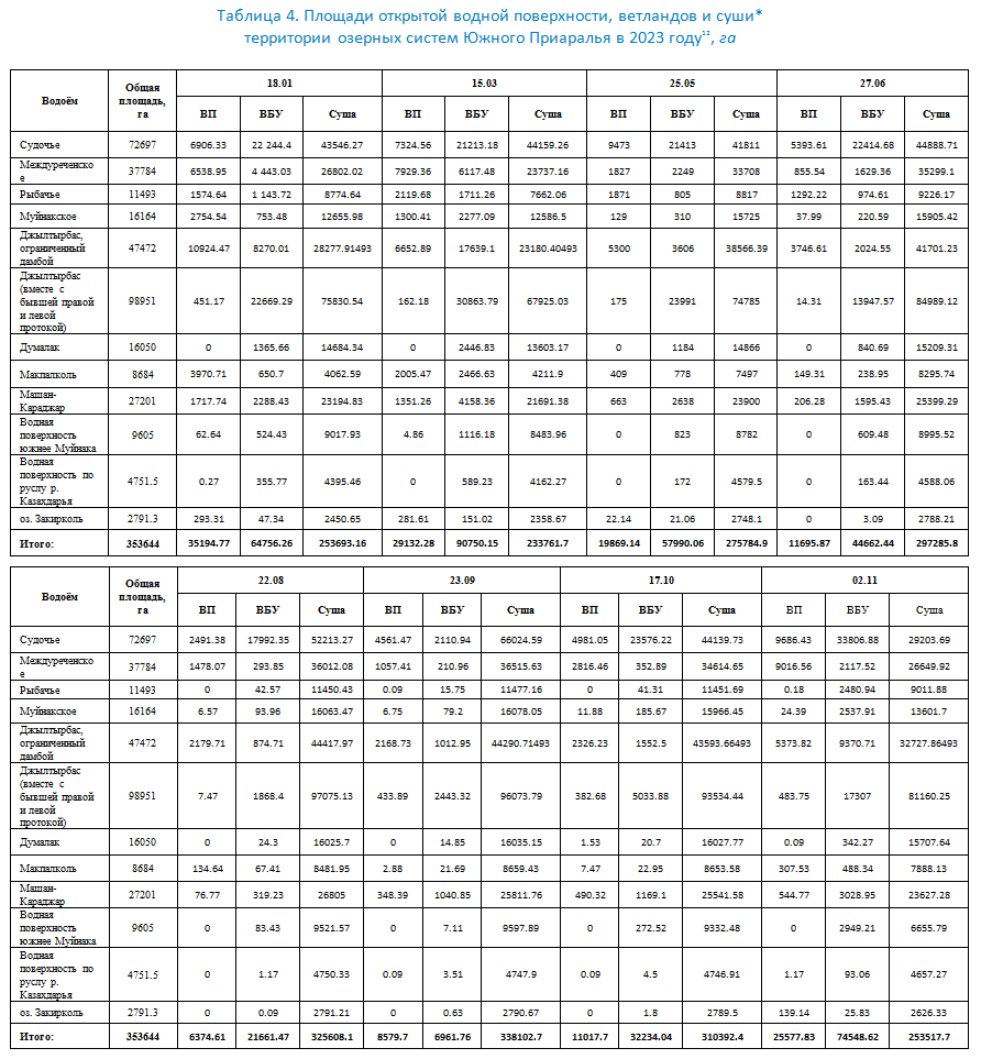
Small local water bodies in the South Aral region comprise the lake systems of the Amu Darya delta. The hydrological situation improved in 2023 compared to 2022. The open water surface area of the lake systems decreased from 35.1 to 25.5 thousand ha, while the wetland area increased from 64.7 to 74.5 thousand ha since January to November (Table 4). Delivering 2,710 Mm3 to the delta is insufficient for fisheries and ecosystem preservation in lakes Sudoche, Rybache, Muynak and Djiltirbas.
The decreased inflow of water from collecting drains into local lakes in the South Aral region was caused by reduced water supply to the Amu Darya delta during the growing season (Figure 2, Table 5).

Conclusion
In 2023, increased water supply to the Amu Darya delta and higher discharge of drainage water from the Main South-Karakalpak Collecting Drain (SKCD) compared to 2022 led to a 98.5 Mm3 increase in inflow to the Large Aral Sea (LAS), from 503.5 to 602 Mm3. However, this total inflow still did not exceed the 650.35 Mm3 recorded in 2021.
By the end of 2023, the Western sub-basin of the LAS experienced a slight decrease in water surface area, while wetland area increased significantly. In contrast, the Eastern sub-basin saw a considerable reduction in water surface area and a minor increase in wetland area. Small local lakes in the South Aral Region continue to face challenges due to unstable water supply.
2.3. Results of Multidisciplinary Expeditions to the Exposed Bed of the Aral Sea in 2019-2023
In 2023, two multidisciplinary expeditions were conducted by SIC ICWC in partnership with the International Innovation Center for the Aral Region (IICAR) under the President of Uzbekistan to study the status of the exposed bed of the Aral Sea , . These expeditions covered 1.5 million ha and were part of the UNDP Joint Program “Empowering youth towards a brighter future through green and innovative development of the Aral Sea region” funded by the UN Multi-Partner Human Security Trust Fund (MPHSTF) for the Aral Sea region.
The expeditions took place from April 25 to May 23 and from September 20 to October 10. Routes were selected based on unsupervised image classification and aligned with prior expeditions conducted in 2019 and 2020. These covered the Akpetka Island system, Lake Karateren, Vozrozhdeniya (Rebirth) Island, the old and new afforestation area, and the zone adjacent to South Karakalpak collecting drain. The team comprised hydrogeologists, soil scientists, geo-botanists, geographers, foresters, and environmentalists. Their work focused on integrated monitoring, including soil and hydrological surveys, geobotanical characterization of vegetation, and remote sensing-based sea landscape decoding and mapping.
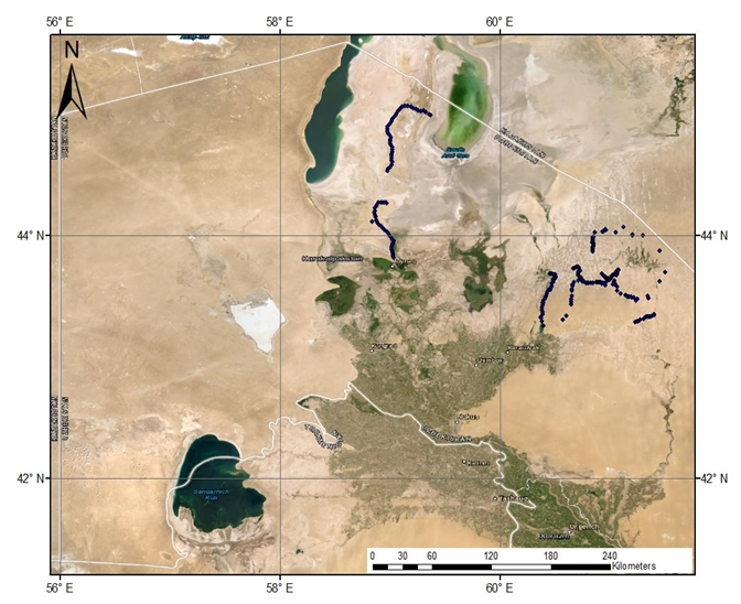
Spring expedition route of 2.5 thousand km (25 April - 23 May 2023)
Coverage: former archipelago, Akpetka Island system, and the exposed seabed
in the Muynak territory of new afforestation area up to Vozrozhdeniya (Rebirth) Island (800 thousand ha)
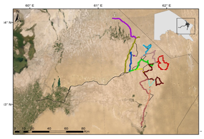
Autumn expedition route of over 2.5 thousand km (20 September - 10 October 2023)
Coverage: the area stretching to the border with Kazakhstan,
including the adjacent zone of the South Karakalpak collecting drain
During ground-based expeditions, the following activities were undertaken: (1) over 2,000 points were documented for image analysis; (2) botanical descriptions and identification of plant formations were conducted; (3) the status of natural vegetation and afforestation was assessed; (4) the overall environmental condition of the study area was evaluated; (5) 49 soil profiles were described and sampled for detailed analysis; (6) the operational hydrological network, including observation wells, pressure wells, and groundwater monitoring points, was monitored; (7) soil and water samples were analyzed in the laboratory.
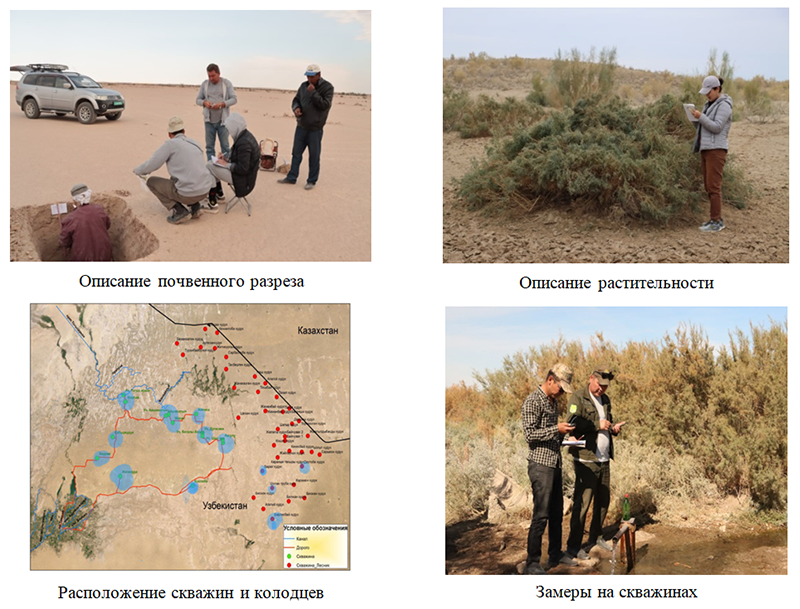
Key findings
1. Geobotanical studies have shown that plant cover on saline soils is increasing due to natural processes that favor the replacement of halophilous plants with psammophilous plants . During the expeditions, a method for afforestation of the exposed seabed using potentially productive plant species was developed to stabilize shifting sands and solonchak. Additionally, the potential of these plant species as a resource base for the republic's pharmaceutical industry was identified.
2. Hydrogeological conditions of the dried seabed are dynamic, influenced by the ongoing decline in sea level and the expansion of the exposed area. Groundwater levels are affected by local water bodies like Lakes Sudoche, Djiltirbas, Muynak, and Rybache, as well as the South Karakalpak collecting drain, Akchadarya, Toguzarkan and other watercourses. Groundwater levels change from the south to the north: from 0.2 to 0.5 m near water bodies and watercourses and gradually decrease towards the current shoreline due to the natural decline in sea level. Groundwater salinity varies from 1.5 to 10 g/l, increasing to 35-75 g/l in the western region. The water chemistry is predominantly chloride-sodium.
Recommendations: (1) establish a comprehensive database documenting all water sources in the region; (2) utilize water from existing self-discharging wells for purposes such as distant-pasture cattle rearing and forestry; (3) develop a roadmap to equip self-discharging wells with regulating devices (gate valves), assign responsible user, and establish a water use regime; (4) increase the number of distant-pasture cattle rearing farms utilizing groundwater with salinity of 2-3 g/l; etc.
3. Afforestation conditions. Afforestation efforts have been undertaken on 1.73 million hectares of the former Aral Sea bed between 2018 and 2023. The success of these efforts varies depending on factors such as planting method (manual, aerial seeding, or machine planting), soil type, groundwater level and salinity, and adherence to afforestation schedules. Root establishment rates for new plantations range from 55-64% in slightly saline soils to 25-30% in moderately saline soils in the Muynak zone. Natural regeneration of saxaul trees has been observed in areas afforested between 2018 and 2020. In the Akpetka zone, where the Suchoche-Akpetka Nature Reserve has been established, root establishment rates reach 65-70%. However, in the Kyzylkum pastures, root establishment rates are lower, around 20%.
Recommendations: (1) implement measures to combat diseases and pests affecting desert forests; (2) establish two research stations for laboratory research and ecological risk assessment on the dried Aral Sea bed; (3) identify suitable areas for sowing seeds of halophyte and xerophyte plants based on comprehensive surveys.
4. Soil cover. The arid climate has led to significant changes in the soil cover since 1990. Hydromorphic salt marshes have decreased by 15.1%, while automorphic salt marshes and sandy areas have increased by 14.6% and 3.5%, respectively. Desert-sandy soils with signs of fertility have expanded by 5.7%. Several areas have been identified as potential sources of dust and salt. Approximately 47% of the total area is characterized by medium to high ecological hazard. This hazard is associated with the fine-grained nature of the soils, which predisposes them to aeolian erosion and accumulation.
Recommendations: (1) implement a differentiated approach to afforestation, selecting plant species based on specific soil conditions; (2) given the relationship between vegetation and soil, a phased approach to developing the drained seabed is recommended. This involves initially planting salt-tolerant plants, followed by the introduction of trees and shrubs.
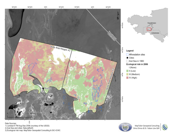
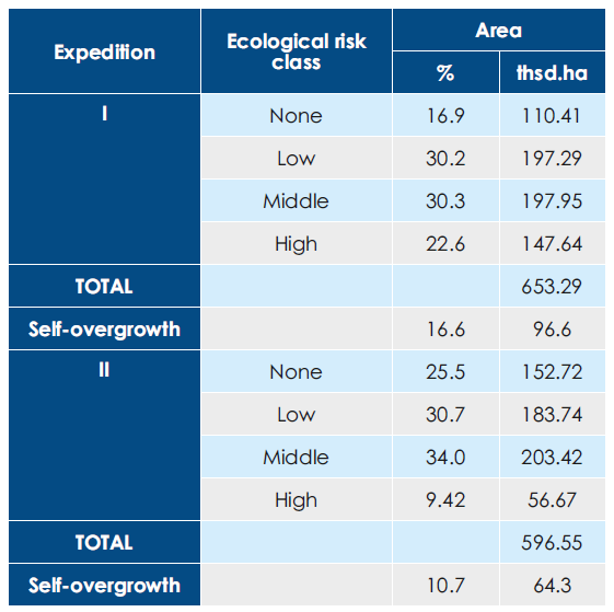
5. Remote sensing research. An innovative mapping method and strategy have been developed to interpret and map the landscapes of the exposed Aral Sea bed. Over 2,800 field samples were collected, documenting coordinates, vegetation types, dominant species, plant layers, soil morphology, and other relevant data. By combining desk studies in ArcGIS 10.8 with the analysis of Landsat 8 OLI images and field observations on geobotany, environment, and soil, maps of ecological hazard were generated, and trends were assessed. Expedition findings indicate that self-overgrowing processes have led to vegetation covering approximately 10% of the exposed seabed.
Conclusion
1. The exposed seabed represents an unsustainable ecosystem that poses significant risks to both the natural environment and public health. The region faces a range of environmental challenges, including aridization, desertification, soil degradation caused by heavy machinery, wind erosion, and the formation of salt sources. However, the landscape is also undergoing natural processes of self-overgrowth and the formation of desert-sandy soils. To effectively address these issues, regular monitoring is essential to provide up-to-date information on the status of the exposed seabed. This information can then be used to inform timely management decisions.
2. Groundwater plays a crucial role in shaping the environmental conditions of the exposed seabed. In this context, it is imperative to continue monitoring groundwater through a network of observation wells and maintain and expand this network.
3. Afforestation efforts are contributing to the transformation of the exposed seabed's soil cover from salt marshes to more fertile and environmentally stable desert-sandy soils.
4. Natural vegetation is undergoing a transition from migratory to stabilizing species. This shift is evident in the replacement of halophytes, which thrive in wet salt marshes, with psammophytes, which are adapted to saline sand environments.
5. The exposed seabed could potentially serve as a resource base for pharmaceutical industry.
6. A significant amount of data, including statistical, cartographic, satellite, and ground-based spatial data, has been collected over the years through expeditions and research on the Aral Sea. To effectively utilize this information, it is necessary to systematize it and create a database and a geo-information platform to support decision-making regarding the natural environment of the exposed seabed.
Prepared by SIC ICWC on the basis of the final report on the expeditions and the Executive Summary “Results of the Final Expedition on the Dried Bed of the Aral Sea”, UNDP, 2024