
Section 2. Water-related situation in the Aral Sea basin
2.1. Water-Related Situation in the Amu Darya and the Syr Darya River Basins
Water Resources
In 2021, the total annual flow in the basins of the Amu Darya and the Syr Darya was 98.49 km3 or 84% of average long-term flow.
Amu Darya Basin
The annual flow in the basin, including the Amu Darya River and its tributaries plus the Zarafshan River, was 66.4 km3, including 52.1 km3 in the Amu Darya River (at the nominal Kerki section located upstream of the Garagumdarya River). The water content of the Amu Darya at this monitoring section was: 71% of the norm in the first quarter; 88% in the growing season; and, 71 % in the first half of the non-growing season 2021-2022.
By the 1st of January 2021, the Nurek and Tuyamuyun reservoirs accumulated 12.37 km3 of water in total.
Syr Darya Basin
The annual flow in the basin, including the Naryn, Karadarya, Chirchik and small rivers, reached 32.09 km3, of which 19.12 km3 in the Syr Darya River (estimated by inflow into three reservoirs – Toktogul, Andizhan, and Charvak).
By the 1st of January 2021, the total water storage by reservoirs in the basin was 25.93 km3, including 13.56 km3 in the key reservoirs in the flow formation zone.
Operation of Reservoir Hydrosystems
The annual inflow into the Nurek reservoir was 19.26 km3, including 15.47 km3 or 80% over the growing season. Water releases from the reservoir amounted to 19.03 km3/year, of which 11.83 km3 or 62% of annual flow was discharged during the growing season.
Because of insufficient flow from the Panj River , the annual inflow into the Tuyamuyun reservoir was 19.71 km3. This inflow was lower than the forecast by 7.75 km3 and 5.4 km3 less for the growing season. Annual water releases from the reservoir were 18.25 km3 or 74% of the value set in the schedule of the BWO Amu Darya. Accordingly, in the growing season the discharge of water from the reservoir made up 13.18 km3 or 74%.
The annual inflow into the Toktogul reservoir located on the Naryn River was 11.59 km3, including 8.76 km3 (76%) over the growing season. Annual water releases from the reservoir amounted to 13.71 km3, and only 5.17 km3 (38%) were discharged from the reservoir during the growing season. Such re-distribution of flow led to emptying of the Toktogul reservoir from 12.24 to 10.1 km3 in the course of the year.
Water Allocation and Shortage
Amu Darya Basin
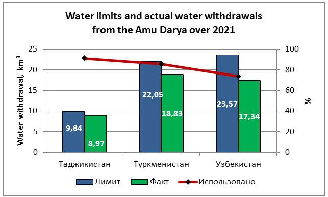
In 2021, given the established limit of water withdrawal from the Amu Darya Basin at 55.45 km3, actually 45.14 km3 (31.38 km3 during the growing season) were diverted. In total, 81% of annual water limit was used. 79% of the established limit of water withdrawal into canals or 39.67 km3 was used during the growing season. The following situation was observed at country level:
• Tajikistan – given the water limit of 9.84 km3, the actual water withdrawal was 8.97 km3 or 91.2%;
• Turkmenistan – given the water limit of 22.05 km3, the actual water withdrawal was 18.83 km3 or 85.4%;
• Uzbekistan – given the water limit of 23.57 km3, the actual water withdrawal was 17.34 km3 or 73.6%.
During the growing season, the water scarcity along the river reach from the Nurek HPP to the Tuyamuyun reservoir was estimated at 10% in Tajikistan, 9% in Turkmenistan, and 18% in Uzbekistan. Turkmenistan and Uzbekistan has received 32% and 37% less water than required, respectively, in the reach from the Tuyamuyun hydroscheme to the Samanbay post. Increased water scarcity along the river during the growing season is explained largely by failure to ensure uniform distribution of water over the territory.
Syr Darya Basin
The total water withdrawal in the Syr Darya Basin amounted to 13.96 km3, including 9.95 km3 or 84% of the established limit (11.85 km3) of water withdrawal into canals during the growing season. No water was discharged from the Syr Darya into Arnasay. The water allocation plan of BWO Syr Darya was fulfilled by 87% on average. In the reach from the Toktogul reservoir to the Chardara reservoir, Tajikistan under-received 22% of water, Kyrgyzstan - 42%, and Kazakhstan and Uzbekistan - 23% and 14%, respectively. The larger water deficit in Kyrgyzstan is explained by the fact that the allocated water limit/quota exceeded the country’s actual water needs.
Inflow into the Aral Sea Region
According to the data of the Kazakhstan’s Committee for Water Resources, in 2021, inflow into the Northern Aral Sea from the Syr Darya was 1.2 km3, and 0.18 km3 were discharged from the Northern Sea into the Large Aral Sea (Eastern part).
Based on SIC's estimates, the South Aral region should receive 8 km3 of water from the Amu Darya in average and wet years and 3.5 km3 in dry years. Actually in 2021, 1.6 km3 or 20% of 8 km3 was delivered to the South Aral region.
River Water Balance Discrepancies
In 2021, the balance discrepancies reached (1) 10.53 km3 in the Amu Darya: 8.54 km3 (6.93 km3 in 2020) during the growing season, and 1.99 km3 (2.49 km3 in 2020) during the non-growing season; (2) 4.31 km3 in the Syr Darya: 0.84 km3 – growing season, and 3.47 km3 - non-growing season. Thus, overall, the river water balance discrepancy decreased by 26% as compared to the previous year (5.85 km3).
Meeting the Demands
The table below shows how water demands for the growing season were met among the CA countries.
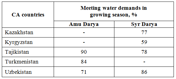
Source: SIC ICWC using the data from BWO AmuDarya and BWO SyrDarya
2.2. Large Aral Sea and the Amu Darya Delta
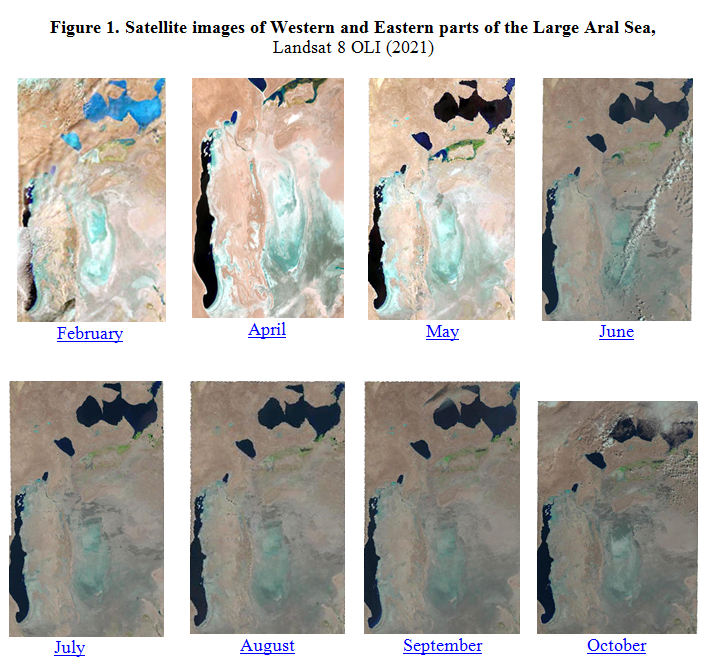
In 2021, SIC ICWC continued monitoring changes in the water surface area of the Eastern and Western parts of the Large Aral Sea (LAS) as well as the lake systems of the Amu Darya delta through Landsat 8 OLI images (http://cawater-info.net/aral/data/monitoring_amu_e.htm).
New Methodology
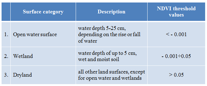
From 2012 to 2019, for identification of sea’s water surface and wetland areas, the satellite data were digitized manually, with following comparison of NDVI (Normalized Difference Vegetation Index). Since 2019, SIC ICWC has been applying a new improved methodology for interpretation of satellite imagery through the supervised pixel classification (AWEI, Automated Water Extraction Index). At the beginning of 2022, it was decided to come back to using NDVI but with the refined threshold values. The principles of the past and new approaches are shown below so that the user could correctly interpret and compare multitemporal data.
Until 2022, the total area of a water body was determined as the sum of open water surface and wetland areas. However, the problem of detecting wetlands, i.e. the possibility to distinguish them from dry land. Therefore, since 2022, the refined threshold values of NDVI have been used to identify three surface categories: 1) open water surface, 2) wetland, 3) dryland. Description and threshold values for those categories are given in the Table below. For classification of water sites the following threshold values were chosen for NDVI from analysis: < -0.001 for open water; -0.001...0.05 for wetland; and, > 0.05 for other land surfaces.
By present, the information for 2021 and 2022 has been updated using the improved methodology. In this context, differences can be found when making comparison with the data for the past years.
2.2.1. Water Supply to the Amu Darya Delta and the Large Aral Sea
Water Supply to the Amu Darya Delta
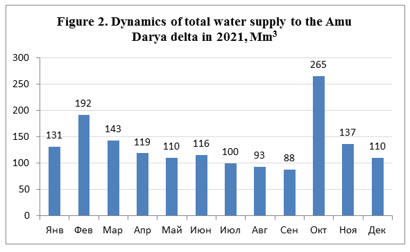
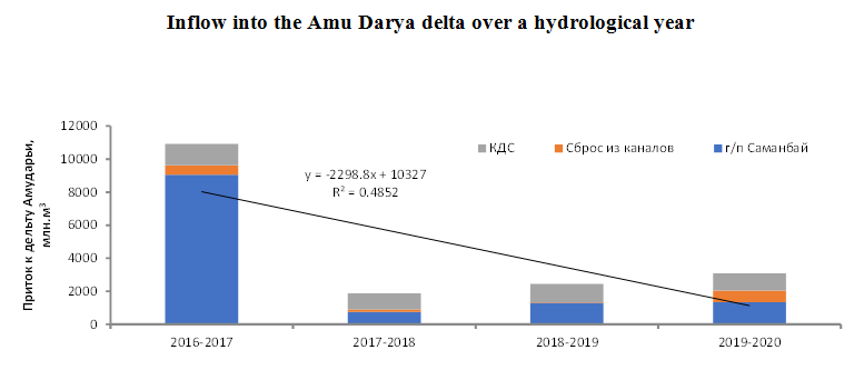
The analysis of water-related situation in the Amu Darya Basin (based on the data of BWO Amu Darya) shows that in 2021, 1,604 Mm3 of water (flow from the river and water discharged from canals and collecting drains) actually reached the Amu Darya delta. This is by 1,089 Mm3 lower than in 2020.
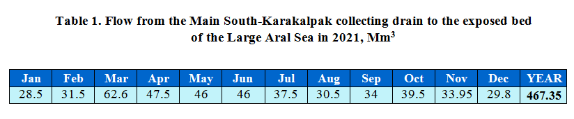
Flow from the Main South-Karakalpak collecting drain to the exposed bed of the Large Aral Sea
Bypassing the Amu Darya Delta, 467.35 Mm3 of collector-drainage water flowed towards the exposed bed of the Large Aral Sea from the Main South-Karakalpak (Right-bank) collecting drain (Table 1) . This is almost 100 Mm3 more than in 2020 (369 Mm3).
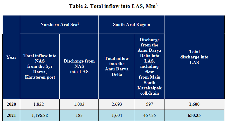
Total inflow into the Large Aral Sea
In 2021, as compared to 2020, the inflow into the Large Aral Sea (LAS) decreased: (1) from the Amu Darya delta , including collector-drainage water from the Main South Karakalpak collecting drain - by 129.35 Mm3, making up 467.35 Mm3; (2) from the Northern Aral Sea (NAS) - from 1003 to as low as 183 Mm3 (Table 2). The total amount of water discharge into LAS decreased 2.4 times from 1,600 (2020) to 650.35 km3 (2021). Water flowing from NAS is partially accumulated in Eastern part, reaches Western part of LAS, and is partially lost through evaporation and infiltration.и.
2.2.2. Open Water Surface and Wetlands in Eastern and Western Parts of the Large Aral Sea
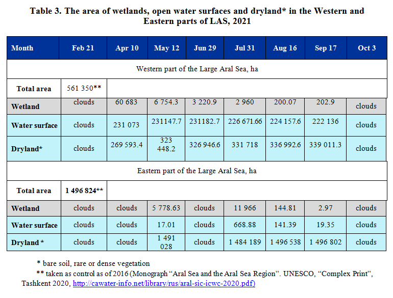
As monitoring and GIS data for 2021 shows, (1) from April to September, the water surface area in Western part of LAS shrank insignificantly from 231.1 to 222.1 thousand ha, while the wetland area decreased dramatically (from 60.7 to 0.2 thousand ha), and the area of the rest part increased 1.26 times (from 314 to 269.6 thousand ha); (2) the water surface area in Eastern part of LAS was within 0.017-0.019 in May and September and 0.67 in July. The wetland area increased almost twofold (from 5.78 to 11.97 thousand ha) and abruptly shrank to 0.003 thousand ha by September (Table 3).
2.2.3. Lake Systems of the Amu Darya Delta
Lake systems of the Amu Darya delta are comprised of small local water bodies in the South Aral region. Overall, as compared to 2020, the hydrological situation in the South Aral region changed for the worse in 2021. The actual water area of the lake systems accounted for 10 (February) to 2.5% (October) of the design area (353 644 ha) . The open water surface area of the lake systems shrank from 34.9 to 8.1 thousand ha in the period of February to October, while the area of wetlands decreased from 4.1 to 0.049 ha (Table 4). The supply of 1,604 Mm3 of water to the Amu Darya delta does not provide necessary conditions for fishery and ecosystem in such lakes as Sudoche, Rybache, Muynak and Djiltirbas. The reason is the lack of a special plan for filling of the lakes with water and the failure to control this process.
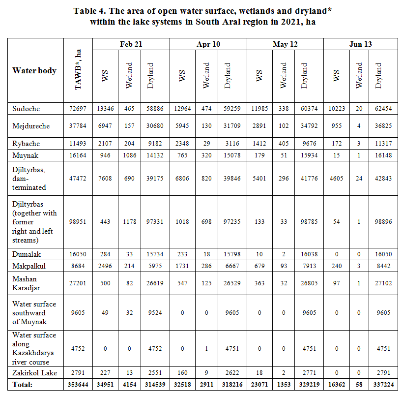
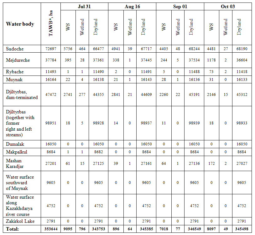
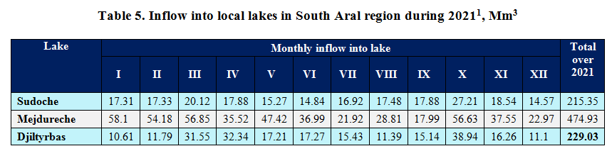
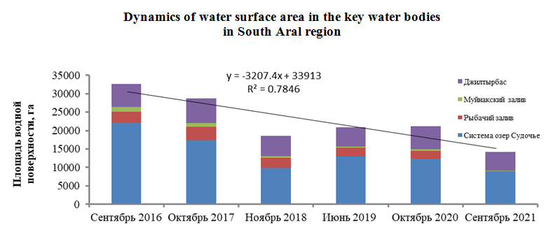
The decreased supply of water to the delta of Amu Darya (Figure 2) during the growing season leads to lower inflow of collector-drainage water into local water bodies in the South Aral region (Table 5).
Conclusion
Dynamics of water surface and wetland area in LAS and South Aral Region in 2021 indicates to the complicated hydrological situation due to variations in water availability in the course of the year. The water surface area of lakes was unstable. In this context, more targeted measures are needed to provide sustainably the right quantity of water for environmental needs of the Aral Sea region and the sea itself. Those are: to complete construction of the deltaic infrastructure in the Amu Darya delta, including the Mejdureche reservoir and the system of lakes to make use of collector-drainage water from the Ozerniy collecting drain; to improve performance of BWO Amu Darya and other basin authorities in lower reaches; to identify water level patterns in the lake systems; and, to develop the system of integrated monitoring combined with application of RS-measurements in the Aral Sea region and the Aral Sea.
2.3. Status of Water Bodies in the South Aral Region
Experts of SIC ICWC set up the expedition from June 10 to July 18 to assess the state of lake systems, such as Sudoche, Djiltyrbas, Muynak, Rybache, and other water bodies in the South Aral Region. They also checked the operation of gauging stations reconstructed by the “CAWa – Central Asian Water” Project in 2011. The expedition’s route extended to about 2,500 km. The expedition covered by observation 80 points in total, including 59 points around/inside water bodies and 21 points at hydraulic structures.

Key findings
The recent measures taken in the Aral Sea Region to create water bodies, construct dams, ensure sound water use, and develop fisheries had been gradually contributing to stable water supply and better environmental and socio-economic situation in the South Aral.
The tasks still to be solved include the following:
1. Ensure sustainable water supply to the South Aral region. The water surface area of lake systems in the Amu Darya delta and the South Aral region has been shrinking every year. Currently, water for environmental needs is provided residually: partially from collector-drainage water and a small amount of river runoff left after meeting the demands of irrigated agriculture. Recently, due to recurrent drought, flow to the Amu Darya delta has decreased. This prevents from providing the minimum amount of water (3.5 km3) as a sanitary flow. Therefore, it is necessary to raise priority of the ecosystem demand, ensure sustainability of water supply, and mobilize additional sources of water.
2. Put the primary focus on better water accounting and modernize and rehabilitate gauging stations. At present, accounting of water losses along main watercourses (rivers, canals and collecting drains) is very rough. As explained by the Delta’s Dike Administration, if a canal or a river is 200 km long then water losses were taken equal approximately 20%. Most gauging stations reconstructed in 2011 under the CAWa Project for measurement of water level and flow rates in canals, collecting drains and water bodies in the Aral Sea region need to be modernized and rehabilitated. Some of gauging stations are out of service, some have no gauge-rods or the latter are not fixed. Thus, it is recommended also to recover canal and collecting drain sections to design parameters, make control measurements of water level and speed to update Q=f(h) curve, equip the gauging stations with automatic sensors for trouble-free data transmission, and provide monitoring services with modern technologies (with bringing staff back).
3. Create favorable conditions for attracting staff and stable financing in improved delta management. There is significant shortage of personnel and financial resources. In 2021, the Delta Authority of the Aral Sea Region reduced its staffing almost twice.
4. Bring uncontrolled waterfowl hunting, bush cutting and dry reed burning to regulation. Herders set fire to reeds to track livestock and expand areas for pastures. However, spontaneously spreading fires damage flora and fauna. Thus, it is necessary to regulate and control burning of dried reeds by setting allowable places and time. RS and drones would also help to identify potentially hazardous places and scale of fire on wetlands. Awareness of the local population should be also raised to prevent fires. Unauthorized hunting and fishing in nature reserves must be strictly prohibited, while nature reserve protection inspectors should get more power, particularly in part of making those who violate the laws on forest and protected natural land accountable.
5. Mobilize the untapped resource of pasturable fish culture to have sustainable revenues and improved status of water bodies. he water bodies in South Aral region can serve a base for pasturable fish culture . Bearing in mind the extended areas of water bodies, that resource could offer great opportunities. Success of pasturable fish culture will depend largely on the arrangement of nurseries for reproduction of baby fish inhabiting these environments.
6. Develop tourism on the Ustyurt Plateau and the coastal strip of Sudoche and treat the regional nature and history with care. The Roadmap for implementation of initiatives voiced by the President of Uzbekistan at the Summit of IFAS founding states included the task for arrangement of a tourist center around Sudoche Lake. In this context, it is necessary to re-start developing relevant design documentation and think on mobilization of investments and grants. In doing this, it is necessary to preserve the historical appearance of the fishing village of Urga used to be a hive of fishermen activity more than half a century ago. Here, one can make use of the touristic experience in the Hula nature reserve (northern Israel), where visitors can watch water birds from an observation tower, and the Rhon biosphere reserve (Germany), with foot paths to enjoy wetland landscapes. The therapeutic potential of saline waters of the Aral Sea region is left unused also. Therefore, the hydrochemical composition of these saline waters (e.g. in the eastern part, Djiltyrbas lake, where the salinity is higher than 120 dS/m) should be thoroughly examined for health resort development.
7. Maintain constant monitoring over the state of water bodies in the South Aral Region through the combination of ground- and RS-based data. The existing monitoring system does not track all changes in the state of water bodies in such a vast area due to lack of accurate maps and weak network of operational observation points and ground-based stations, including meteorological ones. The RS-data can partially solve these problems.
SIC’s experts make monthly assessments of water surface and wetland areas in the South Aral Region and the Western and Eastern parts of the Aral Sea through satellite images. These data are uploaded every month to the SIC’s website. The materials (data matrix with description of 80 GPS points) of this expedition were used to improve the methodology for determining areas of water bodies and wetlands.
The expedition’s report is available on
2.4. Northern Aral Sea and the Aral Sea Region
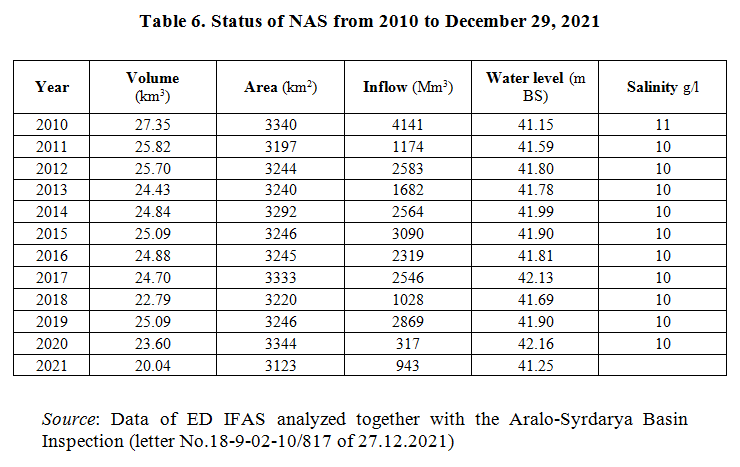
Thanks to the work done under the Syr Darya Control & Northern Aral Sea (NAS) Project, in 2010, the water volume in NAS was 27.35 km3 at the water level of 41.15 m BS, with the water area reaching 3,340 km2. The water salinity was within 11 g/l.
However, since 2010, the catastrophic regression of the Northern Aral Sea has been observed. From 2015 to 2021, the water volume decreased from 25.1 to 20 billion m3 due to reduced inflow caused by natural-climatic conditions and growing water use. Thus, in 2021, the inflow amounted to 943 million m3 only.
From 2010 to 2019, the mean inflow into NAS was about 5.6 billion m3 (as per Karateren gauging station), of which 2.5-3.0 billion m3 were left directly in NAS for maintenance of this water body.
In 2012, over 330 thousand ha of wetlands in the lower reaches of the Syr Darya River and within NAS were enlisted in the List of protected sites of the Convention on Wetlands of International Importance Especially as Waterfowl Habitat (Ramsar Convention). The lake systems and wetlands in the Syr Darya lower reaches consume about 1.5 billion m3 out of required 3.0 billion m3. The expected decrease in water resources in the basin and further growing anthropogenic load may lead to disappearance of the wetlands protected by the Ramsar Convention and to repeated degradation of NAS.
In the future in the Kazakhstan part of the Aral Sea region, if NAS continues to regress and given the hydrological link between surface water and groundwater, usable groundwater resources in Tolagay aquifer may deplete also. This would compromise safe water supplies for 65 settlements in Aralsk and Kazalinsk districts (with population of about 160 thousand). Thus, a strategic environmental assessment needs to be done in this direction, in line with the national Environmental Code, Article 52.
It should be taken into account that recently Turkestan province has seen an increase in the demand for water from the Syr Darya River, including also through the development of the tourism cluster.
By the end of 2020, according to the "Single system of water quality classification for water bodies in the Republic of Kazakhstan", the Syr Darya River (at Kokbulak village site - 10.5 km to the north, north-west of the post) was evaluated as follows: water quality falls to Class 4 (suspended solids - 125.62 mg/dm3, magnesium - 42.79 mg/dm3, sulfates - 510.25 mg/dm3, phenols - 0.0015 mg/dm3); concentration of magnesium and phenols did not exceed the baseline; concentration of sulfates and suspended solids exceeded the baseline.
In 2018-2020, as part of the "Phytomelioration on the Kazakhstan’s dried part of the Aral Sea" Project and together with the Republic of South Korea, saxaul was planted on an area of 13 thousand ha. At the expense of Kyzylorda province budget, 5 thousand ha are afforested every year. In 2020, forest was planted on more than 300 thousand ha in the Kazakhstan part of the dried seabed of the Aral Sea.
Source: ED IFAS in Kazakhstan