
Section 2. Water management situation in the Aral Sea basin
2.1. Water-Related Situation in the Amu Darya and the Syr Darya River Basins
Water Resources
In 2020, the total annual flow in the basins of the Amu Darya and the Syr Darya was 96.44 km3 or 82% of average annual flow.
Amu Darya Basin
The annual flow in the basin, including the Amu Darya River and its tributaries plus the Zarafshan River, was 64.2 km3, of which 49.91 km3 in the Amu Darya River (at the nominal Kerki section located upstream of the Garagumdarya River). The water content of the Amu Darya in this monitoring section was: 82% of the norm in the first quarter; 81% in the growing season; and, 72% in the first half of the non-growing season 2020-2021.
As of the 1st of January 2020, the total water accumulation in the Nurek and Tuyamuyun reservoirs was 13.486 km3.
Syr Darya Basin
The annual flow in the basin, including the Naryn, Karadarya, Chirchik and small rivers, amounted to 32.24 km3, of which 19.38 km3 referred to the Syr Darya River (estimated by inflow into three reservoirs – Toktogul, Andizhan, and Charvak).
As of the 1st of January 2020, the total water storage by reservoirs in the basin was 22.34 km3, including 16.57 km3 in the key reservoirs in the flow formation zone.
Operation of Reservoir Hydrosystems
The annual inflow into the Nurek reservoir was 17.19 km3, including 13.3 km3 (77%) - over the growing season. Water releases from the reservoir were in the amount of 17.39 km3/year, of which 9.47 km3 or 54% of annual flow was discharged during the growing season.
Because of lower flow along the Panj River*, the annual inflow into the Tuyamuyun reservoir was 19.71 km3. This was 7.55 km3 lower than the forecast, including by 6.3 km3 lower for the growing season. Annual water releases from the reservoir were 20.53 km3 or 78% of the value set in the schedule of the BWO Amu Darya. Water releases amounted to 14.15 km3 or 72% during the growing season.
* (Lower flow along the Panj River is possibly explained by increased water diversion by Afghanistan, improper accounting of water along the main course of the Amu Darya or inaccurate evaluation of open-channel losses. The exact causes of such lowering need thorough examination.)
The annual inflow into the Toktogul reservoir located on the Naryn River was 11.68 km3, of which 8.68 km3 (74%) – during the growing season. Annual water releases from the reservoir amounted to 14.41 km3 and only 5.15 km3 (36%) were discharged from the reservoir during the growing season. Such re-distribution of flow led to drawdown of the Toktogul reservoir from 14.94 to 12.24 km3 during the year.
Water Allocation and Shortage
Amu Darya Basin
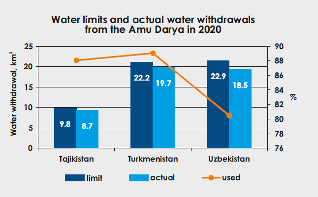
In 2020, given the established limit of water withdrawal from the Amu Darya Basin at 55 km3, actually 46.88 km3 were diverted, including 32.51 km3 during the growing season. 85% of annual water limit was used in total, of which 82% of the established limit of water withdrawal into canals or 39.67 km3 was used during the growing season. The following situation was observed at country level:
• Tajikistan - given the water limit of 9.83 km3, the actual water withdrawal was 19.75 km3 or 88.1%;
• Turkmenistan - given the water limit of 22.19 km3, the actual water withdrawal was 19.75 km3 or 89%;
• Uzbekistan - given the water limit of 22.95 km3, the actual water withdrawal was 18.47 km3 or 80.5%.
During the growing season, in the reach from the Nurek HPP to the Tuyamuyun reservoir the water shortage was estimated at 12% in Tajikistan, 5% in Turkmenistan, and 7% in Uzbekistan. In the reach from the Tuyamuyun hydrosystem to the Samanbay post, Turkmenistan and Uzbekistan has received by 30% and 31% less water, respectively, than they required during the growing season.
Syr Darya Basin
The total water withdrawal in the Syr Darya Basin was 12.41 km3, including 8.9 km3 or 75% of the established limit (11.83 km3) of water intake to canals during the growing season. 0.017 km3 of water were discharged from the Syr Darya into Arnasay. The water allocation plan of BWO Syr Darya was fulfilled by 79% on average. In the reach from the Toktogul reservoir to the Chardara reservoir, the water shortage was estimated at 24% in Tajikistan, 43% in Kyrgyzstan, and 31% and 24% in Kazakhstan and Uzbekistan, respectively.
Inflow into the Aral Sea Region
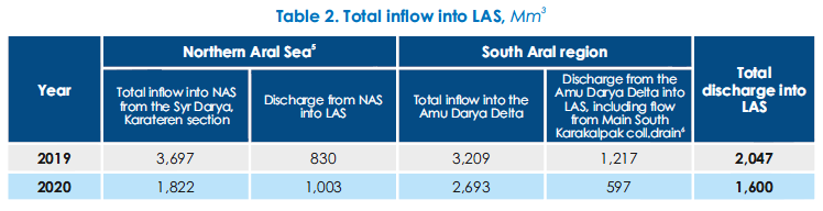
According to the data of the Kazakhstan’s Committee for Water Resources, in 2020, inflow into the Northern Aral Sea from the Syr Darya was 1.82 km3, and 1.0 km3 were discharged from the Northern Sea into the Large Aral Sea (Eastern part).
Based on SIC's estimates, the South Aral region should receive 8 km3 of water from the Amu Darya in average and wet years (in terms of flow) and 3.5 km3 in dry years. Actually in 2020, 2.69 km3 or 34% of 8 km3 was delivered to the South Aral region.
River Channel Water Balance Discrepancies
In 2020, balance discrepancies along the Amu Darya River increased as compared to the previous year: 6.93 km3 during the growing season and 2.49 km3 during the non-growing season or 9.42 km3 in total.
Balance discrepancies along the Syr Darya were estimated at 5.85 km3 (1.11 km3 during the growing season and 4.74 km3 during the non-growing season, i.e. increased by 27% as compared to the previous year (4.59 km3)).
Meeting Demands
The table below shows how water demands were met among the CA countries.
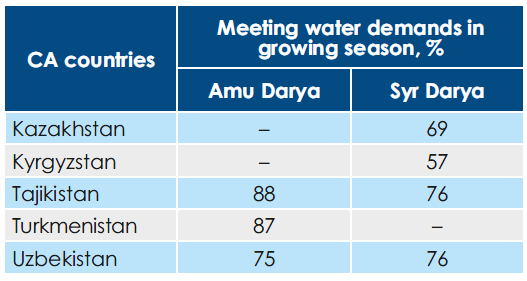
Source: SIC ICWC using the data from BWO AmuDarya and BWO SyrDarya
2.2. Monitoring of Changes in the Water Surface Area of the Large Aral Sea and the Amu Darya Delta
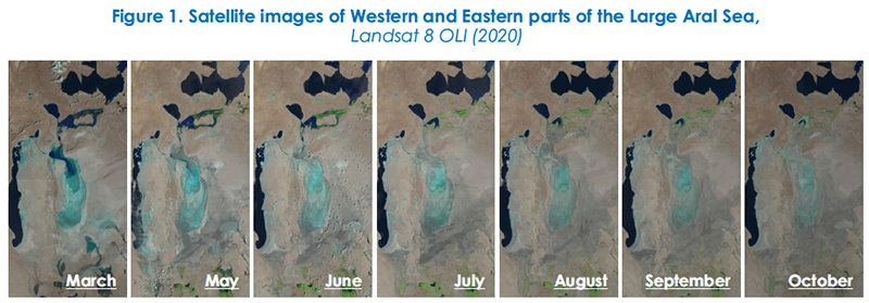
In 2020, SIC ICWC continued monitoring changes in the water surface area of the Eastern and Western parts of the Large Aral Sea (LAS) as well as lake systems of the Amu Darya delta through Landsat 8 OLI images (http://www.cawater-info.net/aral/data/monitoring_amu.htm).
New Methodology
From 2012 to 2019, for classification of sea’s water surface areas, the satellite data were digitized manually, with following comparison of NDVI (Normalized Difference Vegetation Index). Since 2019, SIC ICWC has been applying a new improved methodology for interpretation of satellite imagery by using the AWEI indexes (Automated Water Extraction Index). The new methodology minimizes erroneous interpretation of the area under consideration as a water or land surface (e.g. if plants cover the water surface). Now, water and non-water sites are classified automatically in “R” and GIS on the basis of AWEI. Accordingly, there could be discrepancies in the data over previous years.
2.2.1. Water Supply to the Amu Darya Delta and the Large Aral Sea
Water Supply to the Amu Darya Delta
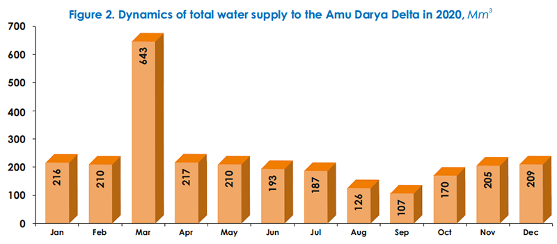
The analysis of water-related situation in the Amu Darya Basin in 2020 (based on the data of BWO Amu Darya) shows that, in fact, 2693 Mm3 of water (flow from the river and water discharged from canals and collecting drains) reached the Amu Darya delta . This is 516 Mm3 lower than in 2019.
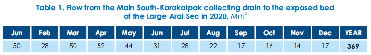
Flow from the Main South-Karakalpak collecting drain to the exposed bed of the Large Aral Sea
Bypassing the Amu Darya Delta, 369 Mm3 of collector-drainage water flowed towards the exposed bed of the Large Aral Sea from the Main South-Karakalpak (Right-bank) collecting drain (Table 1) . This is almost 2.24 times lower than in 2019 (828.3 Mm3).
Total inflow into the Large Aral Sea
In 2020, as compared to 2019, inflow into the Large Aral Sea (1) decreased from the Amu Darya delta, including collector-drainage water from the Main South Karakalpak collecting drain, by 620 Mm3 and made up 597 Mm3; (2) increased slightly from 830 to 1,003 Mm3 from the Northern Aral Sea (NAS) (Table 2). The total amount of water discharge into LAS decreased 1.3 times from 2,047 (2019) to 1,600 km3 (2020). Water flowing from NAS is partially accumulated in Eastern part, also reaches Western part of LAS, and is partially lost through evaporation and infiltration.
2.2.2. Dynamics of Changes in the Open Water Surface and Wetland Area of Eastern and Western Parts of the Large Aral Sea
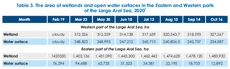
As monitoring and GIS data shows, from February to October 2020, the water surface area in Eastern part of LAS shrank from 76.2 to 12.8 thousand ha (Table 3), while the area of the exposed bed increased by 63.4 thousand ha. The water surface area in Western part also decreased - from 248.8 to 234.0 thousand ha - over the period under consideration (Table 3).
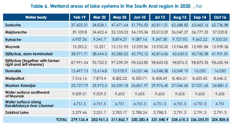
2.2.3. Lake Systems of the Amu Darya Delta
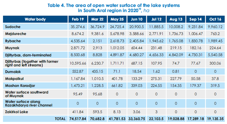
The lake systems of the Amu Darya delta are represented by small local water bodies of the South Aral region. Generally, as compared to 2019, the hydrological situation in the South Aral region changed for the worse in 2020. The open water surface area of the lake systems shrank from 100.1 to 22.6 thousand ha in February-October (Table 4). The actual water area of lake systems accounted for 50% (February) to 10% (October) of the design area.
The supply of 2,693 Mm3 to the Amu Darya delta does not provides necessary conditions for fishery and ecosystem in such lakes as Sudoche, Rybache, Muynak and Djiltirbas. The reason is the lack of a special plan for filling of the lakes with water and the failure to control this process.
The decreased supply of water to the delta (Figure 2) during the growing season leads to lower inflow of collector-drainage water into local water bodies in the South Aral region (Table 5).

The wetland area of the lake systems in South Aral region increased from 279.1 to 334.5 thousand ha over the observation period (Table 6).
Conclusion
Dynamics of changes in the water surface area and wetlands in LAS and Southern Aral Region in 2020 indicates to a complex hydrological situation due to variations in water availability during the year. Moreover, the water surface area of lakes was unstable. In this context, coordinated actions of the riparian countries are needed for water conservation and rational water use in order to deliver the necessary amount of water for environmental needs of the Aral Sea region and the sea itself on a sustainable basis. The required measures include in particular, the following:
• Complete the construction of a deltaic infrastructure in the Amu Darya River delta, including Mejdureche reservoir, and the system of lakes to make use of collector-drainage water from Ozerniy collecting drain;
• Improve accuracy of water accounting as unrecorded losses and balance discrepancies in upper and middle reaches of the Amu Darya amount to 12 km3, on average, reaching 20 km3 in some years (2010 – 20 km3; 2005 – 17 km3);
• Improve performance of BWO AmuDarya and basin organizations in lower reaches;
• Introduce the integrated monitoring system combined with application of RS-measurements for the Aral Sea region and the Aral Sea.
2.3. Expeditions on the Exposed Bed of the Aral Sea in 2019-2020
In 2019, SIC ICWC together with the International Innovation Center for the Aral Region (IICAR) under the President of Uzbekistan organized two expeditions to study the state of the exposed bed of the Aral Sea. The expeditions were funded within the framework of the joint UNDP-UNESCO project “Addressing the urgent human insecurities in the Aral Sea region through promoting sustainable rural development” by the UN Multi-Partner Human Security Trust Fund (MPHSTF) for the Aral Sea region (see “United Nations Development Program”).
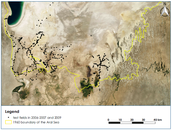
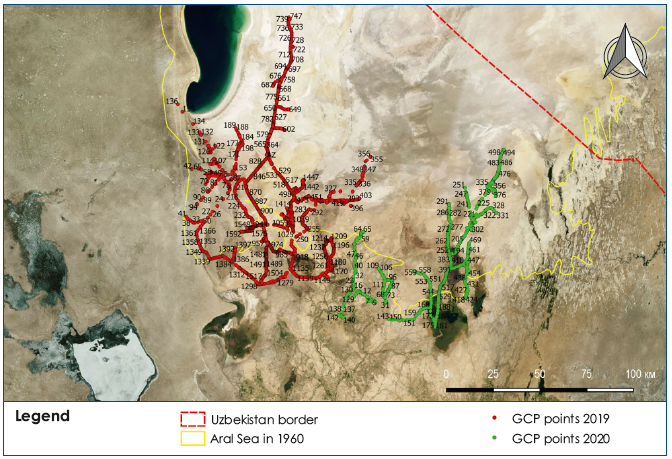
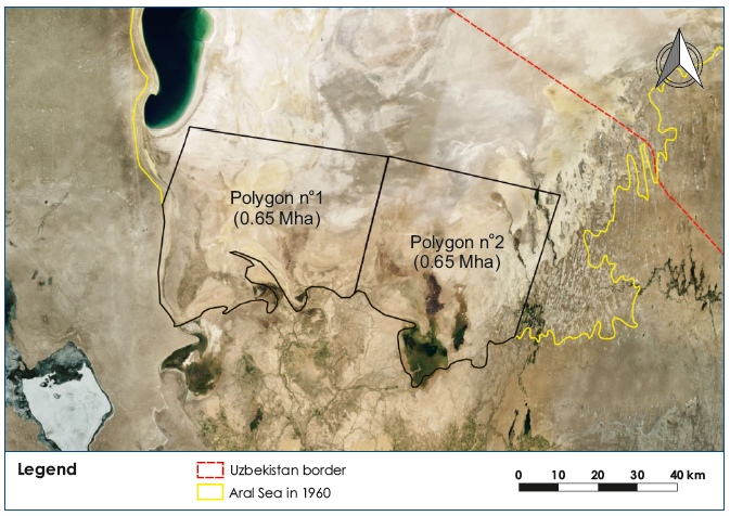
The first (fall) expedition was organized in the “Muynak zone” on an area of 650,000 ha – from the cliff of Ustyurt Plateau to the Amu Darya riverbed, and from the level of 53 m A.S.L. to the water's edge of Western Aral Sea. The expedition took place from 20 September to 20 October 2019 (see 2019 Water Yearbook, section “Results of the Expedition on the Exposed Bed of the Aral Sea in September-October 2019”). The second (summer) expedition was conducted in the “Djiltyrbas zone” from 28 May to 26 June 2020, on an area of 600,000 ha from the Amu Darya riverbed (delta and avandelta) to the Kokdarya River and Togyzarkan stream, from the level of 53 m A.S.L. to the water's edge of Eastern Aral Sea (as close as possible). The total coverage of the study area was 1.25 million ha out of 2.7 million ha in the Uzbek part of the exposed seabed.
The expeditions were multi-disciplinary and included environmentalist, soil expert, hydrogeologist, dendrologist, botanist, and GIS experts. Along with ground-based observations of soil, vegetation, ecology, and groundwater level and salinity, SIC ICWC in cooperation with MapTailor Geospatial Consulting GbR (Fabian Low and Dimo Dimow, Germany) studied the territory using Sentinel and Landsat images. Based on spatial recognition of landscape classes, environmental risk zones were identified and characterized, with following comparison with the study results for 2006.
Field points of expedition routes in 2006-2007 and 2009
Field points of expedition routes 2019-2020
Uzbek part of Aralkum - the area within the coastline of the Aral Sea in 1960. Two polygons of the study area.
Summer expedition – May-June 2020
Two camps were established during the expedition. The first camp was set near Kazakhdarya settlement to cover the route from the Amu Darya riverbed to Djiltyrbas bay. Three sites were studied. The second camp was organized within the boundaries of nearly destroyed GTZ’s central camp. Nine sites were studied from this camp between Djiltyrbas, the Kokdarya River and an area between the Kokdarya and Togyzarkan stream (extension of Kitaiskiy collecting drain).
In the course of the summer expedition, the following work has been completed: comprehensive description of 562 points in situ for image identification; botanical description of vegetation, identification of plant formations; determination of the status of natural vegetation and afforestation, including varieties, height and projective coverage by vegetation; identification of plant self-organization processes; cutting of 21 soil profiles for morphological description of profiles and sampling of soil by henetic horizon; monitoring within operational hydrological network of 2 transects and 6 self-discharging wells, measurement of water table and water sampling; description of environmental conditions of the area and preliminary assessment of environmental risk.
Key findings from the expeditions 2019-2020
The two complex expeditions helped to make geomorphological, hydrogeological, landscape, soil, dendrological and botanic assessments of the 40% of the exposed Aral Sea bed within the boundaries of Uzbekistan (1.25 million ha in southwest and southeast out of 2.7 million ha) and compare the data with the results of 2006–2010 expeditions. Consequently, the following findings could be made:
1. The drying up of the Aral Sea has resulted in degradation of the Amu Darya delta; intensification of desertification processes on vast territories; transportation of salt and dust from the exposed Aral Sea bed; pollution and salinization of water and land resources; shortage of drinking water; depletion of the gene pool of flora and fauna; changes in the climate and landscape in the Aral Sea region; deterioration of the health of population and its gene pool; disappearance of traditional livelihoods, such as fishing and livestock farming, as well as hunting.
2. Both desertification and natural soil formation processes an be observed on the exposed seabed. These processes occur under influence of changes in water table, wind transport, and formation of new soil and vegetation cover.
3. Landscapes become stabilized and substantial land areas transform into higher classes, such as meadows on alluvial plains and shrubs. The area of high ecological risk (class IV) decreased from 505,000 ha in 2006 to 414,000 ha in 2019.
4. Soil characteristics as of 2020. The processes of the Aral Sea desiccation have led to formation of a new soil cover on the dried seabed. The newly formed soil is considered to be radically different from zonal soil, namely in dynamics of soil formation in space and time. The solonchak soil evolution consists of stages. During the last stages, solonchak processes caused by hydromorphic conditions fade out, and the influence of arid-zonal factor increases many times, thus making further soil development run as desert type process. The chain of solonchak transformation ends in formation of desert-sandy soil. The parent rock of the current soil formation on the exposed bed of the Aral Sea is of marine, limnic, alluvial and aeolian genesis.
5. Groundwater regime and salinity depend on distance from the sea and recharge from local lakes. he Aral Sea impacts the groundwater level only within the distance of 15-25 km. In the newly dried area the groundwater level is 3-4 m (data collected from wells drilled in 2019). In more distant points (Muynak area) the groundwater level is 7.9 m (2017) and relies on releases of water from Sudoche Lake and Rybache. Groundwater virtually does not contribute to the Aral Sea balance. According to the recent data, the discharge of groundwater into the Aral depression is minimal (0.12 m3/year).
6. Quantity of plants and taxonomic units is increasing in South Aralkum every year. The plant coverage, with prevailing saxaul, is 32% in the zone of the first expedition and over 60% in the area surveyed by the second expedition, because of higher watering. In the course of the expedition, an approach for afforestation of the exposed seabed by potentially productive plant species (Tamarix hispida, T. ramosissima, Halostachys belangeriana, Haloxylon aphyllum, Salsola dendroides, S.orientalis, Climacoptera aralensis, Nitraria schoberi, Lycium ruthenicum, Limonium otolepis) was developed to stabilize shifting sand and solonchak, and the usability of species in this region as a resource base for republican pharmaceutics was identified.
7. Root-taking of forest plantations is not uniform and varies depending on a way of planting (plane, hang glider or agricultural machine), type of soil, level and salinity of groundwater, and observation of afforestation schedule. The higher tree percent of 64% is observed in the area of the second expedition. The lower tree percent was recorded in strongly saline soil and in furrows that lacked sandy layer.
8. Since 2008, the area of self-organization of plants in the study area has increased by 160 thousand ha and reached 393 thousand ha in 2020. This allows saving about $170 million in the future afforestation. Self-organization of plants is particularly intensive around and at the end of appropriately selected afforested plots (plantations of international projects or State Forestry Committee).
9. The newly formed ecosystem in the exposed seabed is highly impacted by the anthropogenic activity. The positive impact of human activity includes large-scale afforestation and delta conservation measures, while the negative impact is reflected in instability of watering, including desertification and eolian deflation, destruction of already afforested and stabilized risk zone by heavy prospecting and extraction machines and equipment and chopping of saxaul for fuel. All this requires stronger measures from the side of environmental services.
Recommendations
While summarizing the results of the two expeditions, it seems expedient to focus attention of authorized organizations on the following actions and measures:
1. Organize effective governance in the dried up and drying seabed and the Aral Sea region under the overall supervision of the Government of Karakalpakstan. There should be clear division of responsibilities for sustainable water supply (Ministry of Water Management of Uzbekistan in cooperation with BWO AmuDarya), protection of Aralkum ecosystem (State Ecological Committee of Uzbekistan), planning and implementation of afforestation (State Forestry Committee of Uzbekistan), development, use and maintenance of pastures (Ministry of Agriculture). The organized system of governance should prevent further distortion of environmental equilibrium and contribute to stabilization of landscapes through (a) afforestation of the territory subjected to desertification; and, (b) making the area of the former Amu Darya delta sustainable.
2. Organize permanent monitoring of the Aralkum ecosystem and lakes in the Aral Sea region through year-round RS-based and, at least, once a year ground-based observations of environmentally unstable zones. Include this monitoring in the list of regular activities of the International Innovation Center for the Aral Region.
3. For sustainable delivery of water to the exposed seabed and the Amu Darya delta, the following is needed:
a. delivery of required environmental flow to Samanbay section (8 km3 in average year and 4 km3 in dry year) must be ensured, as well as year-round functioning of the constructed water bodies.
b. 3 km3 of drainage water formed in Khorezm oasis in the territory of Uzbekistan should be re-directed from Daryalyk collecting drain to the Amu Darya delta.
4. Pay particular attention to self-organization of plant on the exposed bed and plan future afforestation with due consideration of the former (State Forestry Committee).
5. Make inventory of all available water wells and group them into wells suitable for watering of pastures and those with hot water for balneology.
6. Use the developed methodology of combined remote and ground observations for mapping and quantitative assessment of land cover and for solution of other tasks of territorial management in the context of afforestation of the exposed seabed, including determination of suitability of land for afforestation and monitoring over development of existing or new afforestation sites.
7. Adopt a plan for construction of black roads in the Aral Sea region and on the exposed seabed so that to prevent unauthorized building of local roads and stabilize traffic routes over the territory.
8. Order local authorities of Muynak, Karauzyak, Kungrad and Takhtakupyr districts together with the Government of Karakalpakstan to make inventory of nearly destroyed and abandoned buildings that were previously used by forest farms, fishermen, and pasture farms and think on their new use, probably for tourism, by herdsmen or for development of medical centers.
9. Organize collection and processing of medicinal plants in Aralkum and consider constructing a medicinal plant factory in Muynak town (Ministry of Health of Uzbekistan and the Uzbek pharmaceutical industry).
10. Activate efforts for protection of plants (applying pesticides/biopesticides) against insects, pests and diseases as old and self-organized saxaul vegetation is affected by locust and powdery mildew.
11. Organize integrated ground- and remote-based studies of the remaining area of the exposed seabed (1.5 Mha in the territory of Uzbekistan) in 2021 so that to complete in 2022 mapping of the whole area for development and management of the exposed seabed. Additional expeditions are needed to clarify characteristics of six out of 17 available classes (difficult for interpretation by satellite data) and to classify all 17 initial classes of land cover in northeast, north and northwest parts of the study area to have spatially balanced sampling. This will allow having a full picture of the exposed seabed in Uzbek territory, providing a working tool for organizations responsible for the territorial management and having a single mapping base.
12. Based on the data of past and future expeditions, develop a geoinformation system (GIS) of the dried seabed and the Aral Sea region at IIAC. By using this system, IICAR can effectively coordinate all actions on the exposed seabed for the development of earlier existing sectors, such as fishery, muskrat breeding, livestock breeding, mineral extraction, local building material production and of new ones, like greenhouse farming, medicinal plants, spa treatments, etc.
See details on the expeditions in “Monitoring of the Dried Seabed of the Aral Sea”, eds. by Doctor of Technical Sciences Professor V. A. Dukhovny, Doctor of Biological Sciences G. V. Stulina, and Doctor of Biological Sciences Sh. M. Kenjabayev. Tashkent: UNDP-UNESCO 2020.
Source: SIC ICWC, V.A. Dukhovny and G.V. Stulina (expedition leader)