Murghab River
The Murghab River, also called Margos, Margu and Margiana River, and also transliterated as Murgab and Murgap, is an 850 km long river in Central Asia. It rises in central-western Afghanistan and runs north-west towards the Murghab District, which takes its name from the river, and then the Kara Kum desert in Turkmenistan, where it peters out.
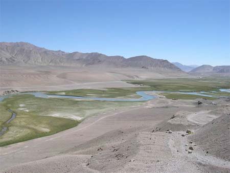
The Murghab originates in central-western Afghanistan, on a plateau situated among the chain of mountains of Paropamisus, Gharjistan and Band-i Turkestan. In its higher course, oriented from east to west, and to the locality of Mukhamedkhan (i.e. over a length of 300 km.), the valley of Murghab is narrow, measuring less than one kilometer in width, with steep slopes. There are narrow gorges in some places. Between Darband-i Kilrekht and Mukhammedkhan, the Murghab crosses the western part of Band-i Turkestan. It then runs toward the northwest in a deep canyon. In Mukhammedkhan, it crosses the gorges of Jaokar. After this, the valley widens somewhat gradually, reaching a width of 2 kilometers in Turkmenistan. Beyond Mukhamedkhan, a small portion of the water of the Murghab is used for irrigation; approximately 10000 hectares are irrigated from the Murghab in Afghanistan. The Murghab receives the waters of the Kaysar river on the right, then forms the border between Turkmenistan and Afghanistan over a 16 kilometer length. In the territory of Turkmenistan, close to Takhta-Bazaar, the Murghab receives the Kachan river from the left bank, and 25 kilometers further, there is the confluence of the Kushk. Reaching the oasis of Merv, the Murghab mingles its waters with those of the Kara-Kum canal (diversion of water from the Amou-Daria).
The flow of Murghab was observed during 50 years (1936-1985) at Takhta-Bazaar, a location in Turkmenistan about thirty kilometers after the Murghab leaves the Afghan territory, and a score of kilometers upstream of the confluence with the Kushk. At Takhta-Bazaar, average annual flow observed over this period was 48.7 m3/second for an observed surface area of 34,700 km2, which is 74% of the totality of the catchment area of the river. The geographically-averaged hydrometric flow passing through this part of the basin, by far greatest from the point of view of the flow, thus reached the figure of 44.3 millimeters per annum, which is very appreciable in this particularly desiccated area.
Monthly mean flows of Murghab (in m3/seconds) measured at the hydrometric station of Takhta-Bazaar
Data calculated over 50 years
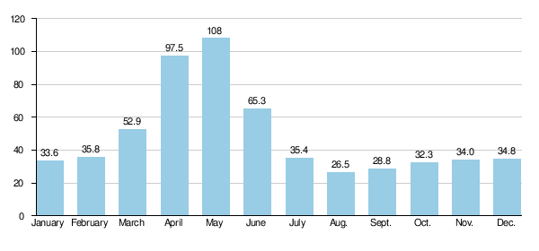
Source: Wikipedia